- 2008 Cadillac XLR Owners Manuals
- Cadillac XLR Owners Manuals
- 2004 Cadillac XLR Owners Manuals
- Cadillac XLR Owners Manuals
- 2007 Cadillac XLR Owners Manuals
- Cadillac XLR Owners Manuals
- 2006 Cadillac XLR Owners Manuals
- Cadillac XLR Owners Manuals
- 2005 Cadillac XLR Owners Manuals
- Cadillac XLR Owners Manuals
- 2009 Cadillac XLR Owners Manuals
- Cadillac XLR Owners Manuals
- Download PDF Manual
-
foliage, bridges, garages, or tunnels may cause loss of XM signal for a period of time. The radio may display NO XM SIGNAL to indicate interference. Cellular Phone Usage Cellular phone usage may cause interference with your vehicle’s radio. This interference may occur when making or receiving phone calls, charging the phone’s battery, or simply having the phone on. This interference is an increased level of static while listening to the radio. If static is received while listening to the radio, unplug the cellular phone and turn it off.
Care of Your CDs Handle CDs carefully. Store them in their original cases or other protective cases and away from direct sunlight and dust. The CD player scans the bottom surface of the disc. If the surface of a CD is damaged, such as cracked, broken, or scratched, the CD will not play properly or not at all. If the surface of a CD is soiled, take a soft, lint free cloth or dampen a clean, soft cloth in a mild, neutral detergent solution mixed with water, and clean it. Make sure the wiping process starts from the center to the edge. Do not touch the bottom side of a CD while handling it; this could damage the surface. Pick up CDs by grasping the outer edges or the edge of the hole and the outer edge.
229
Care of the CD Player Do not use CD lens cleaners for CD players because the lens of the CD optics can become contaminated by lubricants.
Diversity Antenna System The AM-FM antennas are located under the decklid surface in the trunk compartment. The antennas are hidden from view and are not accessible.
If adding an aftermarket cellular telephone to your vehicle, do not attach the antenna to the rear glass. This would interfere with the convertible top retraction operation and could cause damage to the finished/painted surfaces.
XM™ Satellite Radio Antenna System Your vehicle may have the XM™ Satellite Radio antennas that are located in the outside rear view mirrors. These antennas are hidden from view and are not accessible.
230
Section 4
Navigation System
Overview ..................................................... 232
Navigation System Overview ..................... 232
Getting Started .......................................... 234
Features and Controls ................................ 240
Using the Navigation System ..................... 240
Setup Menu .............................................. 243
Plan Route ................................................ 249
Edit Memory Point ..................................... 250
Edit Waypoint ............................................ 254
Edit Avoid Point/Area ................................ 257
Enter Destination ....................................... 259
Route Preference ...................................... 269
Maps ......................................................... 271
Symbols .................................................... 275
Keyless Access System ............................. 280OnStar® System ........................................ 281
Global Positioning System (GPS) .............. 281
Vehicle Positioning .................................... 282
Problems with Route Guidance .................. 283
If the System Needs Service ..................... 283
Ordering Map DVDs .................................. 284
Database Coverage Explanations .............. 284
Navigation Audio System ........................... 285
Six-Disc CD Changer ................................ 302
CD/DVD Player ......................................... 305
Radio Personalization with Home andAway Feature ........................................ 311
Voice Recognition ....................................... 312231
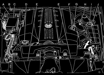
Overview Navigation System Overview
232
A. BAND Key. See “Finding a Station” under
Navigation Audio System on page 285.
B. CD Key. See Navigation Audio System on page 285 or CD/DVD Player on page 305.
C. DVD Key. See “Playing a DVD” under CD/DVD
Player on page 305.
D. TUNE/SEEK Key. See “Playing the Radio”
under Navigation Audio System on page 285.
E. Audio/Adjust Key. See “Main Audio Menu”
under Navigation Audio System on page 285.
F. Power-Volume Knob. See “Hard Keys” under Using the Navigation System on page 240.
G. Navigation System Screen H. RPT (Repeat) Key. See “Hard Keys” under Using the Navigation System on page 240.
I. MAP Key. See “Hard Keys” under Using
the Navigation System on page 240.
J. ROUTE Key. See “Hard Keys” under Using the
Navigation System on page 240.
K. MENU Key. See “Hard Keys” under Using the
Navigation System on page 240.
L. TILT Key. See “Hard Keys” under Using the
Navigation System on page 240.
233
Getting Started Before you begin to operate the navigation system, read this manual thoroughly to become familiar with it and to understand how the system works. Keeping your mind on the drive is important for safe driving. See Defensive Driving on page 322 for more information. Get familiar with your vehicle’s navigation system so you can use it with less effort and take full advantage of its features. Your navigation system includes not only navigation, but also audio functions. While your vehicle is parked: (cid:127) Familiarize yourself with all of its controls: hard
keys on the faceplate and touch-sensitive screen buttons.
(cid:127) Familiarize yourself with its operation. (cid:127) Set up your audio by presetting your favorite stations, setting the tone, and adjusting the speakers. Then, when driving conditions permit, you can tune to your favorite stations using the presets and steering wheel controls (if equipped).
(cid:127) Set up the navigation features that can only be done before you begin driving, such as entering an address or a preset destination.
234
Entering a destination or alphanumeric text requires many steps, so you can only perform these operations when the vehicle is in PARK (P). You will notice that touch-sensitive screen buttons leading to the alphanumeric keyboard are dimmed out while driving. Other functions may also be locked out while driving and they too will appear grayed out on the screen — but all functions are available when parked. Some functions can be performed while driving, as long as you can do so without diverting too much of your attention from your driving.
{CAUTION:
This system provides you with a far greater access to audio stations and song listings. Giving extended attention to entertainment tasks while driving can cause a crash and you or others can be injured or killed. Always keep your eyes on the road and your mind on the drive — avoid engaging in extended searching while driving.
{CAUTION:
Looking at the moving map on the navigation screen frequently or for too long while driving can cause a crash and you or others can be injured or killed. Keep your eyes and mind on the road and avoid looking too long or too often at the moving map on the navigation screen. Use the voice guidance directions whenever possible.
The navigation system allows you to do the following: (cid:127) Plan a route with provided turn-by-turn route and map guidance with voice prompts. See Plan Route on page 249 for more information.
(cid:127) Select a destination using various methods
and choices.
(cid:127) Receive broadcast announcements on traffic
and emergency alert communications.
The information in the system may not always be complete. Road conditions such as prohibited turns, detours, and construction zones, change frequently. It is important to consider whether you can follow the directions given by the system for the current conditions. When getting started, you may set the navigation system to your preference using various options. You will also need to know how to perform various functions to begin route guidance. Reference the following topics for further information: (cid:127) To adjust screen appearance, language, clock,
English/metric measurements, or other options, see “Main Audio Menu” under Navigation Audio System on page 285.
(cid:127) To adjust voice guidance volume or other
navigation settings, see Setup Menu on page 243.
235
Setting Radio Station Presets To set preset radio stations, do the following: 1. Press the PWR/VOL knob to turn the
system on.
2. Press the audio source screen button (AM,
FM1, FM2, etc.) and select the desired band (AM, FM1, FM2, XM1, or XM2 (if equipped), or WX (weather) (if equipped)).
3. Use the TUNE/SEEK arrows to tune to the
desired station.
4. Press and hold one of the six preset screen
buttons, at the bottom of the screen, until you hear a beep or see the station displayed on the selected preset button.
5. Repeat the steps for each preset. See “Preset Station Menu” under Navigation Audio System on page 285 for more information.
Setting the Time To set the time, do the following: 1. Press the PWR/VOL knob to turn the
system on.
2. Press the e / z (Audio/Adjust) hard key. 3. Press the 8 clock symbol screen button. 4. Select the 12H or 24H screen button to display
the time in standard or military time.
5. Press and hold the HOUR and MIN. (minute)
arrow buttons to increase or to decrease the time.
6. Select the appropriate time zone screen
button.
7. Select the Daylight Saving Time screen
button, if necessary.
The radio will use the GPS satellite to set the time. The vehicle needs to be in an open area to receive the signal. See “Clock Adjust Menu” under Navigation Audio System on page 285 for more information.
236
Setting the Search Area, Entering an Address and Point of Interest, Storing a Home Destination, and Using Your Home or Previous Destinations Before entering an Address, Point of Interest, Home, or Preset Destination, select the appropriate region that contains the final destination. Your vehicle must be stopped to perform this operation. Setting the Search Area To set the search area, do the following: 1. Press the PWR/VOL knob to turn the
system on.
2. Insert the DVD map disc. See “Regional Maps” under Maps on page 271 for more information.
3. A notice may appear. Touch the I AGREE
screen button to proceed. If the radio is already on with a map disc inserted, press the ROUTE hard key.
4. Press the Enter Destination screen button.
5. Press the Change screen button. 6. Select the appropriate region numbered
screen button that contains your final destination.
The system will return to the Destination menu. See Enter Destination on page 259 for more information. Entering an Address To set a destination by entering a street address, do the following: 1. Press the PWR/VOL knob to turn the
system on.
2. Insert the DVD map disc. See “Regional Maps” under Maps on page 271 for more information.
3. A notice may appear. Touch the I AGREE
screen button to proceed. If the radio is already on with a map disc inserted, press the ROUTE hard key.
4. Press the Enter Destination screen button.
Verify that the selected Search Area is correct.
5. Press the Address screen button.
237
6. Press the Street screen button, then enter the
street name using the alpha keypad on the screen. Do not enter directional information or street type, and use the space screen button between street or city names. For example, the street name N. Royal Oak Rd. should be entered as royal oak. Use the backspace ( V ) screen button if an incorrect character has been entered.
7. Select the desired street name with the correct
designation (Dr., Ln., St., etc.) from the list.
8. If there is more than one city, the system will
display the list of cities that have that street name. Select a city from the list or select the City screen button to input the city name.
9. Enter the house number using the numeric keypad on the screen and touch the Enter screen button. The system will list the house number range that is available for the street. 10. Press the Enter screen button to plan your
route.
See “Address” under Enter Destination on page 259 for more information.
238
Entering a Point of Interest (POI) To set a destination by entering a Point of Interest (POI), do the following: 1. Press the power/volume knob to turn the
system on.
2. Insert the DVD map disc. See “Regional Maps” under Maps on page 271 for more information.
3. A notice may appear. Touch the I AGREE
screen button to proceed. If the radio is already on with a map disc inserted, press the ROUTE hard key.
4. Press the Enter Destination screen button.
Verify that the selected Search Area is correct. 5. Press the All Points of Interest screen button. 6. Enter the specific title of the POI in the
Name space (i.e. Washington Monument) using the alpha keypad on the screen.
7. Select the POI from the list. 8. Press the Enter screen button to plan your
route. Using the Category or City selections will aid the system in finding your POI by limiting the search options.
See “All Points of Interest” under Enter Destination on page 259 for more information.
Storing a Home Destination 1. Press the power/volume knob to turn the
system on.
2. Insert the DVD map disc. See “Regional Maps” under Maps on page 271 for more information.
3. A notice may appear. Touch the I AGREE
screen button to proceed. If the radio is already on with a map disc inserted, press the ROUTE hard key.
4. Press the Edit Memory Point screen button. 5. Press the Home screen button. 6. Press the Register screen button.
Select a method for entering a destination. See Enter Destination on page 259 for more information.
7. Press the Enter screen button to store the
Home destination. The L Home icon will be highlighted on the DESTINATION screen. See “Using Your Home or Previous Destinations” next to use the home or previous destinations as a route.
Using Your Home or Previous Destinations These destinations are available for selection while driving. 1. Press the power/volume knob to turn the
system on.
2. Insert the DVD map disc. See “Regional Maps” under Maps on page 271 for more information.
3. A notice may appear. Touch the I AGREE
screen button to proceed. If the radio is already on with a map disc inserted, press the ROUTE hard key.
4. Press the Enter Destination screen button.
Verify that the selected Search Area is correct. 5. Select the L (Home symbol) or the Previous
Destination screen button. If the Previous Destination screen button is selected, a list of the last 10 previous destinations will appear. Select the screen button next to the desired destination.
6. Press the Enter screen button to plan your
route.
See “Home” and “Previous Destination” under Enter Destination on page 259 for more information.
239
Canceling Your Current Route Guidance will be canceled once you arrive at your final destination. To cancel the current route prior to arrival at the final destination, do the following: 1. Press the ROUTE hard key. 2. Press the Route Preference screen button. 3. Press the Cancel Route screen button. 4. Press the Yes screen button to confirm
cancellation.
Guidance Volume To adjust the volume of voice guidance prompts, do the following: 1. Press the MENU hard key. 2. Press the ON screen button to turn voice
volume on.
3. Select the desired volume or select the OFF screen button. The system will play back the new volume level.
See “Voice Guidance Volume Settings” under Setup Menu on page 243 for more information.
240
Features and Controls
Using the Navigation System This section presents basic information you will need to know to operate the navigation system. Use the keys located on each side of the navigation screen, as well as the available touch-sensitive screen buttons, to operate the system. See Navigation System Overview on page 232 for more information on location. Once the vehicle is moving, various functions will be disabled to reduce driver distraction. Hard Keys The following hard keys are located to the left of the navigation screen:
BAND: Press the BAND key to access the band screen and switch between AM, FM1, FM2, XM1, XM2, and WX, if equipped. See “Finding a Station” under Navigation Audio System on page 285.
CD: Press the CD key to play a CD. The CD screen will be displayed. See Six-Disc CD Changer on page 302 or CD/DVD Player on page 305.
DVD: Press the DVD key to play a DVD. The DVD screen will be displayed. See CD/DVD Player on page 305. yTUNE/SEEK z: Press the TUNE/SEEK up or down arrows to go to the next or previous radio station and stay there. See “Finding a Station” under Navigation Audio System on page 285. e/ z: Press the audio/adjust key to view the main audio menu. See “Main Audio Menu” under Navigation Audio System on page 285.
PWR-VOL (Power/Volume Knob): Press the power/volume knob to turn the audio and navigation systems on and off. Turn the knob to increase or decrease the volume to the audio system. The following hard keys are located to the right of the navigation screen:
RPT: Press the repeat key to repeat the current voice guidance navigation prompt.
MAP: Press the MAP key to view the map screen showing current vehicle position.
The map screen can also display the following information: (cid:127) North or Heading Up symbol. See Symbols on
page 275.
(cid:127) Map scale. See Maps on page 271. (cid:127) Distance to destination. (cid:127) GPS symbol if GPS signal is not being
received. See Global Positioning System (GPS) on page 281.
(cid:127) Options you have selected for reaching your
current destination. (cid:127) Driver Information. (cid:127) Radio band and presets.
ROUTE: Press the ROUTE key to display the PLAN ROUTE menu. See Plan Route on page 249.
MENU: Press the MENU key to display the SETUP MENU. See Setup Menu on page 243. TILTX: Press the TILT key to open the navigation system faceplate for loading or removing the map DVD, a video DVD, or an audio CD. This key can only be used while the vehicle is in PARK (P).
241
If you are unsuccessful when inputting a name, it may need to be selected differently. It is also possible that the map DVD database may not contain that information or the correct search area has not been selected. See Database Coverage Explanations on page 284 for more information. Touch Sensitive Buttons Touch-sensitive buttons, or screen buttons, are located on the screen. When you have successfully selected a screen button, a beep will be heard. These buttons will be highlighted when a feature is available and dim when they are unavailable. There are some toggle screen buttons that will be light blue when active and dark blue when inactive.
Alpha-Numeric Keypad Letters of the alphabet, symbols, punctuation, and numbers, when available to you, will be displayed on the navigation screen as an alpha or numeric keypad. The alpha keypad will be displayed when the system needs you to input a city or street name. You can also touch Char at the bottom of the alpha keypad to access the numeric keypad when inputting a house address, punctuation mark, or other character. Touch A - Z to return to the alpha keypad. All characters are touch-sensitive screen buttons. Touch a character to select it. Select the space symbol to enter a space between characters or the words of a name.
V: Select the backspace symbol if you have selected an incorrect character. To make your name selections easier, the system will only allow you to select a character which can follow the last one entered. For example, if you enter Z, you would not be allowed to follow it with T. The system will highlight the available characters and darken the unavailable characters.
242
Setup Menu
MENU: Press the MENU key located to the right of the navigation screen to access the SETUP MENU.
Navigation Settings This menu allows you to change the following options for the navigation system.
The SETUP MENU allows you to adjust such things as map appearance, navigation settings, and voice guidance volume.
Restore Default Settings This feature will automatically reset the system to the default values. To restore the default settings, do the following: 1. Touch the Restore Default Settings screen
button.
2. Touch Enter. 3. Touch Return to exit this menu.
243
System Configuration This feature allows you to reconfigure the navigation system. If you begin to drive your vehicle during this procedure, the system will not be able to adjust the position or direction of your vehicle. Touch the System Configuration screen button to view the following choices:
Adjust Vehicle Position: To correct the position of your vehicle on the map or to change vehicle position, do the following: 1. Touch the Adjust Vehicle Position screen
button. The system will display Position Adjustment. The vehicle location symbol and the scroll symbol will appear on the map.
2. Use the scroll symbol and the zoom in/zoom
out feature to locate the vehicle position on the map.
3. Touch Enter to set the vehicle position. The system will display Position Adjustment and two arrows will appear on the map screen.
4. Touch the arrows to adjust the direction of the vehicle. As you touch the arrows, you will see the vehicle symbol direction changing.
244
5. When you have set the vehicle to the correct
direction, touch Enter. Relocation Complete will be displayed.
6. Touch Return to exit this menu.
Calibrate Vehicle Speed Signal: If there are tire pressure differences or if a spare tire is installed, the navigation system will automatically recalibrate the system. You may also choose to calibrate it yourself by doing the following: 1. Touch Start to begin calibration. 2. Touch Return to exit this menu. Time to Destination This feature allows you to view the estimated time to travel from your current position to the destination, and to reset the average speed to factory default settings. Estimated travel time is based on calculated route information and the vehicle’s average speed. Touch ON to turn this feature on, OFF to turn this feature off, or Reset to restore vehicle speed default settings. With this feature on, the estimated travel time to destination will display along with the distance to destination.
Quick POI (Point of Interest) Selection This menu allows you to choose a point of interest (POI), such as gas stations, restaurants, hotels, etc. to be displayed on the map screen. You can also set a destination to a specific POI.
Setting the Quick POI Menu To set the Quick POI list displayed on the map screen, do the following: 1. Select the category you would like to replace. 2. Select a Quick POI category from the
Quick POI selection menu list. The system will return to the Quick POI selection screen when a POI is selected.
3. Touch Return to save the setting and return to
previous menu.
Displaying Quick POI Icons To display POI icons of a category on the map screen, do the following: 1. Touch the map screen once. 2. Touch the POI button. The Quick POI
Selection list will be displayed.
3. Select a category type or touch List
Categories Or All Local POIs to display the icons of the selected category on the map screen.
245
Removing Quick POI Icons To remove POI icons from the map screen, do the following: 1. Touch the map screen once. 2. Touch the POI OFF screen button. The current POI icons will be removed from the map screen.
Setting a Destination Using Quick POI This feature will allow you to choose a POI as your destination. To set a destination using a POI, do the following: 1. Touch the POI icon on the map screen that
you wish to set as a destination. The selected icon will be surrounded by a blinking box, and the name of the icon will be displayed. You may also touch INFO to view the POI name, address, city, and phone number, if available.
2. Touch the ENT DEST screen button.
If a final destination has already been entered, you can add the POI as a waypoint. See Edit Waypoint on page 254 for more information.
3. Touch Enter to start planning your route. 4. To start route guidance, touch Start or begin
driving the vehicle. Route guidance will automatically begin after a short distance.
If you wish to cancel the route you have just set, do the following: 1. Press the ROUTE hard key. 2. Touch the Route Preference screen button. 3. Touch the Cancel Route screen button. 4. Select YES to cancel or NO to continue.
246
Guidance Appearance This menu allows you to set the guidance appearance screen options. This screen is displayed on the map while on a planned route. The current settings will appear as light blue.
Split Map: Select this feature to display the guidance screen on the map at all times.
Full Screen: Select this feature to display the guidance screen on the map when approaching a maneuver.
Turn List: Select this feature to have the guidance screen display several upcoming turns. Directional arrows, street name, and distance to the next turn will be displayed. As you approach the next turn, the system will display a closer view of the upcoming maneuver.
Arrow: Select this feature to have the guidance screen display the next turn. A directional arrow, street name, and distance to the turn will be displayed. As you approach the turn, the system will display a closer view of the upcoming maneuver.
2D: Select this feature to display the guidance screen as a two-dimensional view.
3D: Select this feature to display the guidance screen as a three-dimensional view.
247
Map Appearance This menu allows you to set the map appearance screen options. The current setting will appear as light blue.
Set 3D Viewing Angle: This feature allows you to adjust the 3D viewing angle. To do so, do the following: 1. Touch 3D on the MAP APPEARANCE menu. 2. Touch Set 3D Viewing Angle.
The map screen with the 3D viewing angle bar will be displayed.
3. Touch the up or down arrows to set the
viewing angle.
4. Touch Return to save your settings and to exit
this menu or touch Reset to restore the viewing angle to the default setting.
2D: Select this feature to display the map as a two-dimensional view.
3D: Select this feature to display the map as a three-dimensional view.
248
Plan Route To plan a route, press the ROUTE key. The PLAN ROUTE menu will be displayed.
Voice Guidance Volume Settings This feature allows you to set the voice prompt volume level or to turn voice prompts on or off. Set the voice prompt volume level by touching the numbered buttons to increase or decrease the volume level. You may also choose to turn the voice prompts off. Then touch Return to save your setting and to return to the SETUP MENU. If a voice prompt is active while the audio system is on, the audio system volume will decrease and the voice prompt will be heard through the driver’s side front speaker. Voice prompts will not be heard while using voice recognition.
You may use one of several destination entry methods to plan a route. See Enter Destination on page 259 for more information.
249
Edit Memory Point This feature allows you to store, delete, and edit memory points. Touch the Edit Memory Point screen button from the PLAN ROUTE menu to access the EDIT MEMORY POINT screen.
You can store memory points in four different categories, personal, business, entertainment, and marked point.
250
Memory points are stored when you select either START or MARK when setting a destination on the map or when you are storing destinations in memory. A total of 60 locations can be stored. The last 10 destinations entered will be stored under Previous Destination. In addition, one memory point can be stored under the Home category. If all 60 stored points are entered, the system will notify you that there is no available storage left in memory points. A memory point must be removed before storing additional memory points. Registering Memory Points To store a memory point, do the following: 1. Select a category from the EDIT MEMORY
POINT menu.
2. Touch REGISTER. 3. Select a method for entering a destination. A
map will appear displaying the memory point’s location.
4. If available, touch INFO to view the address
information for the memory point.
5. Touch Enter to store the point.
Editing Memory Points This feature allows you to edit the contents stored in memory. The following options are available: Icon Editing of a Memory Point Each memory point is displayed with a default icon. To edit an icon, do the following: 1. Select the category of the memory point. 2. Select the item you want to edit. 3. Touch the icon. The EDIT MEMORY POINT
icon screen will appear.
4. Touch the icon you would like to use. The
system will then return to the EDIT MEMORY POINT menu.
5. Touch Return to go back to the previous
screen.
You will see the new memory point icon on the map. When selecting an icon, you can choose from 18 different icons, three of which are sound icons. The same icon may be used for other memory points as well.
Name Editing of a Memory Point To modify the name of a stored memory point, do the following: 1. Select the category of the memory point. 2. Select the item you want to edit. 3. Touch the NAME screen button and use the alpha keypad to edit the name. Names may contain up to 15 alpha and/or numeric characters.
4. Touch Return to go to the previous screen. Moving Memory Points To move a memory point from one category to another, do the following: 1. Select the category of the memory point. 2. Select the memory point you want to edit. 3. Touch CATEGORY. A list of categories will
appear. The current category for the item will be highlighted and cannot be selected.
4. Touch the screen button for the category you
want the memory point placed in. A pop-up window will appear displaying the change in category.
5. Touch Return to go back to the previous
screen.
251
3. Touch PHONE and use the numeric keypad
to edit or add the number.
4. Touch the RETURN button to take you back
to the previous screen when you have finished.
Deleting Single Memory Points To delete a single memory point, do the following: 1. Press the ROUTE key. 2. Touch EDIT MEMORY POINT. 3. Select the category of the memory point. 4. Touch DELETE. 5. Select the memory point you want to delete. A
confirmation window will appear.
6. Touch YES to delete the memory point or NO
to return to the previous menu.
7. Touch Return to go back to the previous
screen.
Adjusting a Memory Point To relocate a memory point’s location, do the following: 1. Select the category of the memory point. 2. Select the memory point you want to edit. 3. Touch POSITION. A map screen with
the position of this memory point will appear. 4. Touch anywhere on the screen to activate the scroll feature and relocate the memory point. See Maps on page 271.
5. Touch Enter to save the memory point’s new
location.
6. Touch Return to go back to the previous
screen.
Changing the Phone Number of a Memory Point To edit or add the phone number of a memory point, do the following: 1. Select the category of the memory point. 2. Select the memory point you want to edit.
252
Deleting All Memory Points To delete all of the memory points in a category, do the following: 1. Press the ROUTE key. 2. Touch EDIT MEMORY POINT. 3. Select the desired category. 4. Touch the DELETE ALL screen button. A
confirmation window will appear.
5. Touch YES to delete the memory points or
NO to return to the previous menu.
6. Touch Return to go back to the previous
screen.
Edit Category To edit the name of a category, do the following: 1. Press the ROUTE key. 2. Touch EDIT MEMORY POINT. 3. Select the category you want to edit.
4. Touch the EDIT CATEGORY screen button
and use the alpha keypad to edit the category name. The name can consist of up to 15 alpha and/or numeric characters.
5. Touch Return to go back to the previous
screen.
Marked Point A marked point is a memory point which has been stored by selecting the MARK screen button while traveling on a planned route. You can also use the scroll feature to plan a destination on the map after reaching the destination, or by moving a memory point to a marked point category. See “Editing Memory Points” earlier in this section for more information.
253
Previous Destination Memory Each time you select Start from the map screen, that destination will be stored as a memory point under PREVIOUS DESTINATION. This category will store up to 10 destinations. When the Previous Destination category contains more than 10 destinations, the system will remove the oldest destination stored and add the most recent one selected to the list. If you do not want a previous destination to be lost, you must move the destination into a memory point category. See “Moving Memory Points” earlier in this section for more information. Home Memory This memory point is stored by selecting Home from the EDIT MEMORY POINT screen. See “Registering Memory Points” earlier in this section and “Home” under Enter Destination on page 259
for more information.254
Edit Waypoint Waypoints are destinations you can set along the way to your final destination. This feature allows you to add, edit, and delete waypoints.
You may set up to five waypoints on the way to your final destination. To access the WAYPOINT menu, do the following: 1. Press the ROUTE key. 2. Touch Edit Waypoint.
Adding a Waypoint To add a waypoint to your route, do the following: 1. Touch Add Waypoint. 2. Enter a destination. See Enter Destination on
page 259. A map will appear showing the location of the waypoint.
3. Touch Enter to add your waypoint. 4. Touch the ADD screen button to insert the
waypoint in the desired order.
5. The system will display the ROUTE
INFORMATION screen. From this screen, several options are available.
List: Touch List to view the waypoint on the map or to change the order of the waypoints and final destination. To change the order, touch CHG ORDER, then touch the blank screen button next to the destination to select the order of the waypoints and final destination. Press the MAP key to view the destination and waypoints on the map screen.
Delete: Touch Delete to delete a waypoint or the final destination. A confirmation window will appear. Touch YES to delete the point or NO to return to the previous screen.
255
Delete All: Touch Delete All to delete all of the waypoints and the final destination. A confirmation window will appear. Touch YES to delete all waypoints or NO to return to the previous screen.
Change: Touch Change to change the final destination. Enter a destination. See Enter Destination on page 259.
Add: Touch Add to add additional waypoints. Refer to the steps for adding a waypoint listed previously in this section.
Calculate: Touch Calculate to begin route calculation. This feature will only be available if the final destination has been set.
Editing a Waypoint This feature allows you to edit waypoints that have already been set. To edit a waypoint, do the following: 1. Touch Edit Waypoint. 2. Touch the MAP key to view the destination
location on the map screen.
3. Touch CHANGE ORDER to change the order
of the waypoints and the final destination. You can also use the map scroll to change a waypoint from one location to another.
Deleting a Waypoint To delete a waypoint from your route, do the following: 1. Touch Delete Waypoint. 2. Select the waypoint you want to delete. A
confirmation window will appear.
3. Touch YES to delete the waypoint or NO to
return to the previous menu.
256
Edit Avoid Point/Area From this menu you can register, edit, and delete an area to be avoided while planning a route. These areas can also be saved so the system can automatically avoid them when planning a route.
Registering an Avoid Point/Area To store an avoid point/area, do the following: 1. Touch Register Avoid Point/Area. 2. Enter a location. See Enter Destination on
page 259.
3. If desired, reduce or enlarge the area around
the point you want to avoid by using the REDUCE or ENLARGE screen buttons. If an avoid point cannot be avoided, the system will display “Avoid Point and Area Stored. Route May Not Avoid the Avoid Point and Areas.”
4. Touch Enter to set the area as an avoid point area. When using the REDUCE or ENLARGE buttons, a box will appear to represent the area or an X will appear to represent the area avoided. When an avoid point is set, the square will appear as green.
5. Touch Return to go back to the previous
screen.
257
To access the AVOID POINT/AREA menu, do the following: 1. Press the ROUTE key. 2. Touch Edit Avoid Point/Area.
Editing an Avoid Point/Area To edit an avoid point/area, do the following: 1. Touch Edit Avoid Point/Area. A list of avoided
points will appear.
Deleting an Avoid Point/Area To delete an avoid point/area, do the following: 1. Touch Delete Avoid Point/Area. A list of
avoided points will appear.
2. Select the avoided point/area you want to
change. A map of the avoided area will appear.
3. Use REDUCE or ENLARGE to edit the
avoided point.
4. Touch Enter to set your new avoided area.
The system will display “Area Adjusted.” 5. Touch Return to go back to the previous
screen.
2. Select the avoided point/area you want to
delete.
3. The system will ask you to confirm your selection. Touch Yes to delete the avoid point/area or No to cancel. If Yes is selected, the area will no longer be avoided when traveling on a planned route.
4. Touch Return to go back to the previous
screen.
258
Enter Destination The DESTINATION menu will give you several ways to plan a route. Touch the Enter Destination screen button from the PLAN ROUTE menu to display the DESTINATION menu.
For destination entry methods listed on the second page of the DESTINATION menu, touch the Next Page arrow. Touch the Prev. Page arrow to return to the first page. To enter a destination, choose from one of the destination entry methods following in this section.
After entering a destination, If available, the system will display up to three routes in a pop-up window indicating the total mileage and time to destination for each route. Select a route by touching NEXT. The map will display each route in a different color. The selected route will be highlighted in red. To start route guidance, touch Start or begin driving your vehicle. Route guidance will automatically begin after a short distance. If you touch CHG ROUTE before touching Start, you will be able to change route preferences. See Route Preference on page 269 for more information. When a route has been planned, it will be highlighted and a bulls-eye symbol will appear on the map to show your final destination. If you wish to cancel a route that has been set, see “Cancel Route” under Route Preference on page 269.
259
Easy Planning Route With this destination entry method, you can select a destination using the scroll symbol on the map screen. See Maps on page 271.
To use this destination entry method, do the following: 1. Press the MAP key. 2. Touch the map screen twice for the scroll symbol to appear. Touch the map or drag the scroll symbol toward your destination.
3. Touch the map screen continuously to scroll through the map faster. The address of the location on the map will appear at the top of the screen. If needed, use the zoom feature to locate your destination. See “Map Scales” under Maps on page 271 for more information.
4. Touch ENT DEST to set this location as your
destination. You may also touch MARK to store this location as a memory point.
5. Touch Enter to plan your route.
260
Address This destination entry method allows you to input an address by providing the system with a house number, street name, and city. Select Street to begin entering the desired address.
To use this destination entry method, do the following: 1. Enter the street name using the alpha keypad. See “Alpha-Numeric Keypad” under Using the Navigation System on page 240 for more information.
Do not include name extensions such as N. or Drive. For example, the street name N. Civic Center Drive should be entered as Civic Center. As information is entered, the system will automatically search for available names, and List will become available.
2. Touch List to view name choices or continue
to spell the street name to further reduce the number of available items. Select a street name.
3. If the street name you entered exists in more
than one city on the DVD database, a list of cities will appear. You can select a city from the list, or enter the city name by selecting City. As you begin to enter the city name, you can select the desired city from the list which will appear, or continue to spell the city name to further reduce the number of available items. 4. Once the city name has been selected, enter the house number using the numeric keypad. The system will list the house number range that is available for the street.
5. When you have finished entering all of the
address information, touch Enter to plan your route.
261
All Points of Interest This destination entry method allows you to choose a destination from the point of interest (POI) list. Selecting All Points Of Interest from the DESTINATION menu will bring up the alpha keypad. While inputting a POI or city name, the List option will become available. As information is entered, the system will search for available POI and city names based on the information given. The system will supply a list of names to make a selection from when the choices are five or less.
You may search for a POI using the following three methods: (cid:127) Touch NAME to type in a POI by name using
the alpha key pad. As you type in a name, the system will search for an available match to your input. Select the desired POI.
(cid:127) Select a POI by touching CATEGORY. Use the arrows to scroll through the categories listed. Select a category along with any appropriate sub-categories. If the list of available POIs for the selected category is too long, you may need to enter the POI’s name or city.
(cid:127) Select CITY, then type in the city you wish to select a POI from. Choose a city from the list of cities that will appear. If the list of POIs for the selected city is too long, enter the POI’s name or choose a category.
While inputting a POI or city name, the List option will become available. Touch List to view the list of name choices, or continue to spell the name to further reduce the list of available items.
262
The system will list all POIs available. You can sort by name using NAME SORT or touch DIST SORT to list POIs by distance from your current location.
Memory Points This destination entry method allows you to set a memory point as your destination. Each time you store a destination from the map screen, the destination is stored under MARKED POINT. See Edit Memory Point on page 250 for more information.
Select a location from the list. The system will show the selected POI on the map. If available, a pop-up window will be displayed. Touch INFO to view the POI’s name, address, city, and phone number, if available. Touch Enter to plan your route.
You must have destinations stored as memory points to select from PERSONAL, BUSINESS, ENTERTAINMENT, or MARKED POINT. If you have renamed the memory point category name(s), the name(s) will appear as you changed them.
263
To select a destination using this entry method, do the following: 1. Touch the Memory Points symbol. 2. Select a category. 3. Select a destination. Use the arrows to scroll
through the memory points. They can be sorted by date, name, distance, and icon.
4. Touch Enter to plan your route. Previous Destination This destination entry method allows you to select a destination by choosing from a list of the last 10 destinations entered into the system.
264
To select a previous destination, do the following: 1. Touch the Previous Destination symbol. 2. Touch the screen button next to the desired
destination to select it. Use the arrows if necessary to view the entire list of previous destinations.
3. Touch Enter to plan your route.
Previous Starting Point This destination entry method allows you to select the last start point as your destination. To select the previous start point as your destination, do the following: 1. Touch Previous Destination. 2. Touch the Previous starting point screen
button.
3. Touch Enter to plan your route. Home This destination entry method allows you to select a destination that has been previously stored as Home.
To choose Home as your destination, do the following: 1. Touch the Home symbol. 2. Touch Enter to plan your route.
265
Set by Map This destination entry method allows you to select a destination by using the scroll symbol.
2. Use the scroll symbol to select the desired
destination. The zoom in and zoom out feature can be used to assist you in finding the desired location. See “Map Scales” under Maps on page 271.
3. Touch Enter to plan your route. Freeway Entrance/Exit This destination entry method allows you to select either a freeway entrance or an exit as a destination.
To use this feature, do the following: 1. Touch the Set By Map symbol. Current
vehicle position will be shown on the map screen.
266
4. Select a freeway from the list. 5. The ENTRANCE or EXIT options will appear. Choose ENTRANCE to select the entrance to the freeway, or EXIT to select the exit ramp of the freeway. When either button is touched, it will give an alphabetical list of freeway entrance and exit ramps on the freeway you entered. You may touch DIST SORT to sort the list by distance from your current location, or NAME SORT to sort the list by name.
6. Select the desired freeway entrance or exit
from the list. A map will appear with the destination shown.
7. Touch Enter to plan your route.
To enter a freeway name, do the following: 1. Touch the Freeway Entrance/Exit symbol. 2. Enter the freeway name using the alpha
key pad. Freeways sometimes have a name and a number associated with them which you may need to refer to when entering freeway information. Freeways are also referred to by their abbreviated names. For example, Interstate 75 in the U.S. is selected by entering I-75. As you enter a freeway name, the List option will become available.
3. Touch List to view the list of available name
choices or continue to spell the name to further reduce the list of available items. The system will supply a list of names when the choice is five or less. If you are unsuccessful when inputting a name, the name may need to be input differently, the map DVD database may not contain this information, or the name may be misspelled.
267
Intersection This destination entry method allows you to select a destination by inputting the intersecting roads you wish to travel to.
To enter an intersection, do the following: 1. Touch the Intersection symbol. 2. Using the alpha keypad, enter the name of
the first street in the intersection.
268
3. To view a list of choices, touch List or
continue to spell the name to further reduce the list of available items. The system will display a list of the intersecting streets if the number of intersecting streets is five or less.
4. Select the first street. 5. Now enter the second street name. 6. Select the second street name from the list of intersecting streets. To view a list of choices, touch List or continue to spell the name to further reduce the list of available items. The system will display a list of intersecting streets if the number of intersecting streets is five or less. If there are multiple intersections with the same two roads, the system will display a list of cities to choose from. Choose a city from this list. A map with the intersections for that city will appear.
7. Touch Enter to plan your route.
Route Preference To change your planning options, use the following instructions.
The following options will be available from the ROUTE PREFERENCE menu: Detour This feature allows you to choose a distance in miles/kilometers to detour. Select the detour distance desired for residential roads and freeways.
1. Press the ROUTE key. 2. Touch Route Preference.
The system will retain these settings for the next time you use Detour, unless you change them. You may also touch Alternate to provide a new route that does not use previously stored detour settings. Touch Return to go back to the previous screen.
269
Route Setting This feature allows you to display and change the planning methods used each time you plan a route. With planning method options, you are able to select the fastest route based on time or distance, using only major roads, toll roads, and using ferries based on the navigation system’s information and information contained on the map DVD.
The following options will be available from the ROUTE SETTING menu:
Minimize Time/Distance: The system will calculate the fastest route or shortest route possible. Choose Time for the fastest route or Dist for the shortest route.
Use Major Roads: Choose Yes to calculate the best route using only major roads unless a route cannot be found without the use of a secondary road. This selection will not always offer the shortest distance or time to your destination.
Use Toll Roads: Choose Yes to calculate the best route using toll roads wherever possible. This selection will not always offer the shortest distance or time to your destination.
Use Ferries: Choose Yes to calculate the best route using ferries when possible. This selection will not always offer the shortest distance or time to your destination.
270
Display Whole Route This feature allows you to display your entire planned route. Total mileage and time to destination for the planned route will be displayed on the map screen. Touch Return to go back to the previous menu. Calculate Route This feature allows you to begin route calculation for the selected destination. Cancel Route If you are traveling on a planned route and would like to cancel it, touch Cancel Route. The system will ask you to confirm by touching YES. Touch YES to confirm cancellation of your planned route or touch Return to keep your planned route.
Maps This section includes basic information you need to know about the map database.
Regional Maps The maps are stored on a DVD-ROM. The 48 contiguous United States and portions of Canada are contained on one disc. The U.S. map database includes interstate freeways, state highways, country roads, and major and general streets. Refer to the “Navigation System Map Disc” manual to view the explanation of map coverage and detailed city lists in each region. The map disc manual will be in your map DVD case when the vehicle is delivered from the factory. Installing the DVD Map Disc When your vehicle is delivered from the factory, the dealer may have installed the map DVD. If the map DVD was not installed in your vehicle when first purchased, do the following: 1. Turn the ignition on. 2. With the vehicle in PARK (P), press and hold
the TILT key until a beep is heard. The system’s faceplate will open.
3. If already loaded, the map DVD or a CD will
eject from the slot.
271
4. Load the map DVD into the slot by inserting it
partway. The system will pull it in.
5. Press and release the TILT key to close the
faceplate.
Notice: Shifting out of PARK (P) with the system’s faceplate open will cause the faceplate to close automatically. This could cause damage to a CD, DVD or the system if it is partially loaded. Before shifting out of PARK (P), make sure that the DVD or CD is loaded properly. The vehicle must be shifted back into PARK (P) to close the faceplate. Once the map DVD is inserted correctly, you will have the following two choices: (cid:127) LANGUAGE (cid:127) You can change the language at this time. See “Language” under Navigation Audio System on page 285 for more information on choosing a language. Once a language has been selected, touch I AGREE to plan a route. The map will appear showing your current vehicle position.
I AGREE
Ejecting the DVD Map Disc When the DVD map disc is not loaded, you will not be able to use the navigation portion of the system. 1. Turn the ignition on. 2. With the vehicle in PARK (P), press and hold
the TILT key until a beep is heard. The system’s faceplate will open.
3. The map DVD will eject from the slot. Pull the
disc out.
4. Press and release the TILT key to close the
faceplate.
Notice: Shifting out of PARK (P) with the system’s faceplate open will cause the faceplate to close automatically. This could cause damage to a CD, DVD or the system if it is partially loaded. Before shifting out of PARK (P), make sure that the DVD or CD is loaded properly. The vehicle must be shifted back into PARK (P) to close the faceplate.
272
Setting the Search Area To determine or change the system’s search area, do the following: 1. Press the ROUTE key. 2. Touch the Enter Destination screen button.
3. Touch Change
under the Search Area heading. The system will display a map with each region represented.
4. Select the desired region by touching the appropriate screen button to the left of the U.S. map. The name of the states or the country included in the selected region will be displayed at the bottom of the screen and the region will be highlighted.
5. Touch Enter to set the region as the
search area.
6. Touch Return to go back to the previous
screen.
273
Map Adjustments The system allows you to adjust the scale of view on the map. The map will scroll automatically based on the direction you are traveling. Map Scales
Scrolling the Map
Touch anywhere on the map screen twice to display the scroll symbol.
To view a larger or smaller scale of the map, touch the map scale arrows.
You may also adjust the scale of the map by touching the scale on the bar. The scale of a map can range from 1/32 of a mile (0.05 km) to 128 miles (256 km).
274
Place your finger on the map screen in any direction outside of the scroll symbol to scroll in that direction. The map will continue to scroll until you remove your finger. If your vehicle is in PARK (P), the system will initially scroll at a slower rate. The rate will increase if you continue to touch the map screen. If your vehicle is in motion, there is one scroll speed and a limited distance to scroll. You must keep touching the map screen to scroll a longer distance. If your vehicle icon becomes lost while scrolling, press the MAP key to show the vehicle’s current location. You may also use the scroll feature to set a destination. See “Set by Map” under Enter Destination on page 259.
Symbols The following symbols are the most common that appear on a map screen.
You will see this type of symbol on the map when a waypoint has been planned.
Your vehicle is shown as this symbol. It indicates the current position and heading direction of your vehicle on the map.
This symbol will appear on the map to show your destination after a route has been planned.
The waypoint symbol will be numbered from 1 through 5 depending on how many waypoints have been set. See Edit Waypoint on page 254 for more information on adding waypoints.
This symbol indicates the distance to your final destination.
See Enter Destination on page 259 for more information on planning a route.
275
This symbol indicates the distance and estimated travel time to your final destination. The Estimated Travel Time feature must be on for estimated travel time to be displayed.
This symbol indicates the distance to your final destination in a straight line.
This symbol will appear before route guidance begins or if you are on a road where route guidance is not available.
276
This symbol indicates the map with North up.
While in North up mode, North will always be at the top of the map screen regardless of which direction the vehicle is traveling.
This symbol indicates the map with the vehicle travel direction up, or Heading up.
The shaded triangle indicates North. While in Heading up mode, the direction your vehicle is traveling will always be at the top of the map screen. Touch either the North Up heading symbol or the vehicle Heading Up symbol to alternate between settings.
This symbol will appear when the navigation system is unable to receive the GPS signal.
See Global Positioning System (GPS) on page 281
for more information.When a point of interest (POI) or street address name is too long to be displayed, an arrow will appear.
Touch the right or left arrow to scroll through the entire name.
This symbol indicates the position of the next turn instruction.
While on a planned route, touch this symbol to display the DEST MAP, WHOLE, and TURN LIST options.
277
With these options, you can do the following:
Dest (Destination) Map: This option allows you to view the final destination location. The destination’s name or address will be displayed on the map screen. Touch Return when finished.
Whole: This option allows you to view the entire planned route. The distance to destination will be displayed on the map screen. Touch Return when finished.
278
screen as you make each turn. You may also touch the scroll up and down arrows providing scroll is available. Touching the down arrow will bring you to your current location. Touching the up arrow will give you upcoming streets. At times, there may not be names available for entrance or exit ramps. To avoid a turn, touch AVOID next to the turn you want to avoid. You can use REDUCE or ENLARGE to edit the avoided point. Touch Reroute or press the MAP key to calculate your new route. Touch Return to view your current position and to turn the turn list screen off. Touch REROUTE or press the MAP key to calculate a new route. Auto Reroute When your destination is set and you travel off of the planned route, the system will automatically begin to reroute you. You will see the new route highlighted on the screen.
279
Turn List: This option allows you to view a step-by-step listing of upcoming street names, the distance that you will travel on the road, and turns you will need to make during your planned route. After touching Turn List, the system may take some time to create the list. The length of time will vary depending on the length of your route and the planning methods you have selected. The turn list will read from bottom to top. The bottom street name is the street you are currently on. The system automatically updates this
Traveling Across Regions If you plan to drive across several states, you may have to change the selected region to represent the area you are traveling to. There are two ways you can plan a destination when traveling across regions. The following method is suggested and provides the most route guidance and map display functions: 1. Change the selected search area region when you get closer to the area you are traveling to. See “Setting the Search Area” under Maps on page 271.
2. Enter your destination and route settings. See
Enter Destination on page 259 for more information.
If you do not want to use the first method, keep your currently selected search area region and enter your destination. This method allows you only to select a destination from the easy planning route method or from the All Points of Interest (POI) categories with the “All Search Areas” comment for US Only. For example, Tourist
280
is a category that features this comment. See Enter Destination on page 259 for more information. If you are traveling in or to Canada and you cross the regional border, the only map scale views available are 4 mi, 8 mi, 31 mi, and 128 mi (8 km, 16 km, 64 km and 256 km). Change the selected search area region when you get closer to the area you are traveling to. See “Setting the Search Area” under Maps on page 271 for more information.
Keyless Access System When the engine is started, Driver 1 or Driver 2
will display on the screen. A message will not appear on the screen if the driver is unknown. The number on the back of the transmitter corresponds to driver 1 or driver 2. The navigation system can store memory points for drivers 1 and 2 individually. See Keyless Access System on page 67 for more information.OnStar® System When using the OnStar® system, the audio system will be muted and the navigation voice prompts will be disabled during the call. The volume of the OnStar® call can be adjusted by using the steering wheel volume controls. See OnStar® System on page 107 for more information.
Global Positioning System (GPS) The Navigation System determines the position of your vehicle by using satellite signals, various vehicle signals, and map data. At times, other interferences such as the satellite condition, road configuration, the condition of the vehicle and/or other circumstances can interfere with the Navigation’s ability to determine the accurate position of the vehicle. The GPS shows the current position of your vehicle using signals sent by the GPS Satellites of the United States Department of Defense. When your vehicle is not receiving signals from the satellites, a symbol will appear on the map screen. Refer to Symbols on page 275.
This system may not be available or interference may occur if the following happens: (cid:127) Signal obstructions caused by tall buildings,
large trucks, tunnels,
(cid:127) objects located on top of the instrument panel, (cid:127) satellites will not send signals if they are
being repaired or improved,
(cid:127) after-market glass tinting has been applied to
the vehicle’s windows.
Notice: Do not apply after-market glass tinting to the vehicle’s windows. Glass tinting will interfere with the system’s ability to receive GPS signals and cause the system to malfunction. You might have to replace the window to correct the problem. This would not be covered by your warranty. For more information if you are experiencing a problem, see If the System Needs Service on page 283 and Problems with Route Guidance on page 283.
281
(cid:127) The vehicle is entering and/or exiting a parking lot, garage, or a lot with a roof.
(cid:127) The GPS signal is not received. (cid:127) A roof carrier is installed on your vehicle. (cid:127) The vehicle is being driven with tire chains. (cid:127) The tires are replaced. (cid:127) The tire pressure for your tires is incorrect. (cid:127) The tires are worn. (cid:127) The first time the map DVD is inserted. (cid:127) The battery is disconnected for several days. (cid:127) The vehicle is driving in heavy traffic where driving is at low speeds, and the vehicle is stopped and started repeatedly.
If you experience problems with your system, see your dealer.
Vehicle Positioning At times, the position of the vehicle on the map may be inaccurate due to one or more of the following reasons: (cid:127) The road system has changed. (cid:127) The vehicle is driving on slippery road
surfaces such as in sand, gravel, and/or snow.
(cid:127) The vehicle is traveling on winding roads. (cid:127) The vehicle is on a long straight road. (cid:127) The vehicle is approaching a tall building or a
large vehicle.
(cid:127) The surface streets run parallel to a freeway. (cid:127) The vehicle has just been transferred by a
vehicle carrier or a ferry.
(cid:127) The current position calibration is set
incorrectly.
(cid:127) The vehicle is traveling at high speed. (cid:127) The vehicle changes directions more than once, or when the vehicle is turning on a turn table in a parking lot.
282
Problems with Route Guidance Inappropriate route guidance may occur under one or more of the following conditions: (cid:127) You have not turned onto the road indicated. (cid:127) Route guidance may not be available
when using automatic rerouting for the next right or left turn.
(cid:127) The route may not be changed when using
automatic rerouting.
(cid:127) There is no route guidance when turning at an
intersection.
(cid:127) Plural names of places may be announced
(cid:127)
occasionally. It may take a long time to operate automatic rerouting during high-speed driving.
(cid:127) Automatic rerouting may display a route
returning to the set waypoint if you are heading for a destination without passing through a set waypoint.
(cid:127) The route prohibits the entry of a vehicle due
to a regulation by time or season or any other regulation which may be given.
(cid:127) Some routes may not be searched. (cid:127) The route to the destination may not be
shown if there are new roads, if roads have recently changed, or if certain roads are not listed on the map DVD. See Ordering Map DVDs on page 284.
To recalibrate the vehicle’s position on the map, see your dealer.
If the System Needs Service If your system needs service and you have followed the steps listed here and still are experiencing problems, see your dealer for assistance.
283
Ordering Map DVDs You will receive two free DVD map disc updates with the purchase of your new vehicle. Updates are necessary to make sure that your vehicle’s navigation system has the most accurate information available about streets/roads, points of interest, and business locations. The updates are provided by the GM Nav Disc Center at the first and second anniversary dates of your vehicle’s delivery date. About four to six weeks before those anniversary dates, you will receive a post card from the GM Nav Disc Center reminding you that a free update is available. The center will request confirmation of your mailing address either by having you contact the toll-free number, 1–877–NAV–DISC (1–877–628–3472), or the center’s website, www.gmnavdisc.com. After verifying your address you should receive the updated disc in about two weeks. After receiving the updated disc, replace the old disc in the navigation system. See “Installing the DVD Map Disc” and “Ejecting the DVD Map Disc” under Maps on page 271. Dispose of the old disc to avoid confusion about which disc is the most current.
If you have any questions about the operation of the navigation system or the update process, call the GM Nav Disc Center or go to the center’s website. If you need any future updates or a replacement disc, because the current disc is lost, damaged, or needs to be updated, call the GM Nav Disc Center or order a new disc online. To order a disc, have your Vehicle Identification Number (VIN) available. This helps the center make sure you receive the correct and most up to date DVD map disc for your vehicle. See Vehicle Identification Number (VIN) on page 451
for more information.Database Coverage Explanations Coverage areas vary with respect to the level of map detail available for any given area. Some areas will feature greater levels of detail than others. If this happens, it does not mean there is a problem with the system. As the map DVD is updated, more detail may become available for areas which previously had limited detail. See Ordering Map DVDs on page 284.
284
Main Audio Menu
e/ z(Audio/Adjust): Press this key to view the main audio screen.
Navigation Audio System Notice: Before adding any sound equipment to your vehicle, such as an audio system, CD player, CB radio, mobile telephone, or two-way radio, make sure that it can be added by checking with your dealer. Also, check federal rules covering mobile radio and telephone units. If sound equipment can be added, it is very important to do it properly. Added sound equipment may interfere with the operation of your vehicle’s engine, radio, or other systems, and even damage them. Your vehicle’s systems may interfere with the operation of sound equipment that has been added. Your vehicle has a feature called Retained Accessory Power (RAP). With RAP, the audio system can be played even after the ignition is turned off. See Retained Accessory Power (RAP) on page 89 for more information. The audio system is operated using navigation system menus. The audio menus are explained in this section.
285
Display Presets on the Map: With this feature on, your audio system presets for the current audio source will be displayed on the left of the map screen. Touch ON to turn this feature on. You may also choose to turn this feature off. With this feature on, you can recall your preset radio stations from the map screen. You cannot store preset stations from the map screen. You must do this from the audio screen. See “Preset Station Menu” later in this section for more information on storing presets.
Automatic Volume Control (AVC): The system has Bose AudioPilot® noise compensation technology. AudioPilot® monitors the level of noise in the vehicle and automatically increases or decreases the level of audio to keep it audible above the noise. To use AudioPilot®, press the ON screen button. To turn it off, press the OFF screen button.
Preset Selection: Here you can program the audio system’s presets to recall your home settings by touching HOME. You can also recall the presets you use when traveling to another area by touching AWAY. See “Preset Station Menu” later in this section for more information on how to store preset stations. The Home and Away feature is not available for the XM™ Satellite Radio source, if equipped.
286
This feature is most effective at lower volume settings where background noise can affect how well you hear the music being played through your vehicle’s audio system. At higher volume settings, where the music is much louder than the background noise, there may be little or no adjustments by AudioPilot®. For additional information on AudioPilot®, please visit www.bose.com.
8(Clock): Touch this screen button to get to the CLOCK ADJUST menu. See “Clock Adjust Menu” later in this section for more information.
SCREEN ADJUST: To adjust the brightness or contrast of the screen, touch SCREEN ADJUST to display the screen adjust menu. See “Screen Adjust Menu” later in this section for more information.
SOUND: Touch this screen button to access the Sound menu. See “Sound Menu” later in this section for more information.
DSP (Digital Signal Processing): Touch this screen button to access the DSP menu. See “Adjusting the Speakers” later in this section for more information.
Clock Adjust Menu
The following options are available from this menu:
HOUR/MIN.: Touch the up or down arrows to increase or decrease the hour or minutes. If you touch and hold one of the arrows, the numbers will advance quickly.
12H/24H: Touch 12H to set the clock in standard time or 24H to set the clock in military time.
287
GPS TIME: The current GPS time will be displayed to the right of this screen button. Touch GPS TIME to set the navigation system time to match current GPS time. If the seconds for the present minute are greater than thirty when GPS TIME is selected, the clock will round up to the next minute.
Daylight Saving Time: Touch this screen button to increase the time setting by one hour. Then touch GPS TIME to save the new setting. If the screen button is light blue, the daylight savings time feature is on. If the button is dark blue, the daylight savings time feature is off.
TIME ZONE: The selected time zone will appear to the right of this screen button. Touch this screen button to toggle between time zones and select the desired one. The time of the selected zone will be displayed to the right of the GPS TIME screen button. To set the clock to the new setting, touch GPS TIME. If the system is not receiving GPS information, you can still set the time manually as described above but the GPS time and Daylight Saving Time features will not be available. Touch Return to go back to the previous menu.
288
Screen Adjust Menu
The following options are available from this menu: K(Contrast): Touch the plus (+) or minus (−) signs to adjust the contrast of the screen. You will see the screen change. Touch SET to confirm the setting. !(Brightness): Touch the plus (+) or minus (−) signs to adjust the brightness of the screen. You will see the screen change. Touch SET to confirm the setting.
AUTO: This setting automatically adjusts the contrast and brightness of the screen depending on exterior lighting conditions.
DAY: This setting leaves the screen in day mode. Day mode is best suited for daylight conditions.
NIGHT: This setting leaves the screen in night mode. Night mode is best suited for nighttime conditions.
SCREEN OFF: Touch SCREEN OFF to turn off the screen. Press any hard key to turn the screen back on.
SET: Touch SET to save your choices and exit the CLOCK ADJUST menu. Language Your vehicle has been set for the English language. If you wish to change the language, you must do so through the Driver Information Center (DIC). See Driver Information Center (DIC)