- 2008 Cadillac XLR Owners Manuals
- Cadillac XLR Owners Manuals
- 2004 Cadillac XLR Owners Manuals
- Cadillac XLR Owners Manuals
- 2007 Cadillac XLR Owners Manuals
- Cadillac XLR Owners Manuals
- 2006 Cadillac XLR Owners Manuals
- Cadillac XLR Owners Manuals
- 2005 Cadillac XLR Owners Manuals
- Cadillac XLR Owners Manuals
- 2009 Cadillac XLR Owners Manuals
- Cadillac XLR Owners Manuals
- Download PDF Manual
-
the interior of the vehicle, the doors will lock after eight seconds. For example, if there are two keyless access transmitters in the vehicle and one is removed, the other will be locked in. The keyless access transmitter locked in the vehicle can still be used to start the vehicle or unlock the doors, if needed. A person approaching the outside of the locked vehicle without an authorized keyless access transmitter, however, will not be able to open the door, even with a transmitter in the vehicle. You may temporarily disable the passive door locking feature by pressing the door unlock switch for three seconds on an open door. Passive door locking will then remain disabled until a door lock switch is pressed or until the power mode transitions from the off power mode. You can select to not have the horn sound when the passive lock occurs. If you choose this setting, the doors will automatically lock eight seconds after you turn the ignition off, remove a keyless access transmitter from the interior of the vehicle, and close both doors. You can also select to have the horn sound once when the passive lock occurs. If you choose this setting, the doors will automatically lock and the horn will chirp eight seconds after you turn the ignition off, remove a keyless access transmitter from the interior of the vehicle, and close both doors.
3-74
If you are parking in a quiet area and do not want the horn to sound when the doors lock, press the lock button on the keyless access transmitter immediately after removing it from the interior and closing the doors. This will lock the doors and cancel the passive locking for this ignition cycle. The DIC will display PASSIVE LOCKING OFF, SILENT PASSIVE LOCK, or HORN AT PASSIVE LOCK. Press the OPTIONS button to change the setting. Passive Unlocking This feature allows you to select which doors will automatically unlock when you approach and open the driver door with the keyless access transmitter. You can choose to have the driver door unlock or both doors unlock. See Door Locks on page 2-10 for more information. The DIC will display PASSIVE UNLK DRIVER or PASSIVE UNLK BOTH. Press the OPTIONS button to change this setting. Auto Unlock This feature automatically unlocks either the driver door or both doors, depending on the setting, when the shift lever is moved to P (Park). The DIC will display AUTO UNLOCK OFF, AUTO UNLOCK DRIVER, or AUTO UNLOCK BOTH. Press the OPTIONS button to change the setting.
Park Assist This feature tilts the passenger side mirror downward when the shift lever is moved to R (Reverse). This can help you to see the curb while backing up. If you adjust the mirror while in R (Reverse), the new position will be saved as the park assist position. The DIC will display PARK ASSIST OFF or PARK ASSIST ON. Language This feature allows you to select the language the DIC and Head-Up Display (HUD), uses to display messages. The DIC will display ENGLISH, FRENCH, GERMAN, ITALIAN, JAPANESE, or SPANISH. Press the OPTIONS button to change the setting. If you become stuck in a language that you do not understand, hold the OPTIONS and RESET buttons for five seconds. The DIC will scroll through all available languages for as long as the buttons are held. Each language option will display in its own language. For example, English will be displayed as ENGLISH, Spanish as ESPANOL, etc. When the desired language is available, release the buttons and the DIC will set to this language.
3-75
Trip Computer
Oil Life Indicator This feature lets you know when to change the engine oil. It is based on the engine oil temperatures and your driving patterns. To see the display, press the information button several times until OIL LIFE appears. If you see 99% OIL LIFE, 99 percent of the current oil life remains. The DIC may display a CHANGE OIL NOW message. If you see CHANGE OIL NOW, it means the oil life is gone. For more information, see Scheduled Maintenance on page 7-4 and Engine Oil on page 6-15. When the oil is changed, you will need to reset the system. See Engine Oil Life System on page 6-18. Always keep a written record of the mileage and date when you changed your oil.
Audio System(s) Read the following pages to become familiar with the audio system’s features.
{ CAUTION:
Taking your eyes off the road for extended periods could cause a crash resulting in injury or death to you or others. Do not give extended attention to entertainment tasks while driving.
This system provides access to many audio and non audio listings. To minimize taking your eyes off the road while driving, do the following while the vehicle is parked: (cid:129) Become familiar with the operation and controls of
the audio system.
(cid:129) Set up the tone, speaker adjustments, and preset
radio stations.
For more information, see Defensive Driving on page 5-2.
3-76
Notice: Contact your dealer/retailer before adding any equipment. Adding audio or communication equipment could interfere with the operation of the vehicle’s engine, radio, or other systems, and could damage them. Follow federal rules covering mobile radio and telephone equipment. The vehicle has Retained Accessory Power (RAP). With RAP, the audio system can be played even after the ignition is turned off. See Retained Accessory Power (RAP) on page 2-25 for more information.
Bluetooth® Vehicles with a Bluetooth system can use a Bluetooth capable cell phone with a Hands Free Profile to make and receive phone calls. The system can be used while the key is in ON/RUN or ACC/ACCESSORY position. The range of the Bluetooth system can be up to 30 ft. (9.1 m). Not all phones support all functions, and not all phones are guaranteed to work with the in-vehicle Bluetooth system. See gm.com/bluetooth for more information on compatible phones.
Voice Recognition The Bluetooth system uses voice recognition to interpret voice commands to dial phone numbers and name tags.
Noise: Keep interior noise levels to a minimum. The system may not recognize voice commands if there is too much background noise.
When to Speak: A short tone sounds after the system responds indicating when it is waiting for a voice command. Wait until the tone and then speak.
How to Speak: Speak clearly in a calm and natural voice. Audio System When using the in-vehicle Bluetooth system, sound comes through the vehicle’s front audio system speakers and over-rides the audio system. Use the audio system volume knob, during a call, to change the volume level. The adjusted volume level remains in memory for later calls. To prevent missed calls, a minimum volume level is used if the volume is turned down too low.
3-77
Bluetooth Controls Use the buttons located on the steering wheel to operate the in-vehicle Bluetooth system. See Audio Steering Wheel Controls on page 3-88 for more information. b g (Push To Talk): Press to answer incoming calls, to confirm system information, and to start speech recognition. c ª(Phone On Hook): Press to end a call, reject a call, or to cancel an operation. Pairing A Bluetooth enabled cell phone must be paired to the in-vehicle Bluetooth system first and then connected to the vehicle before it can be used. See the cell phone manufacturers user guide for Bluetooth functions before pairing the cell phone. If a Bluetooth phone is not connected, calls will be made using OnStar® Hands-Free Calling, if available. Refer to the OnStar owner’s guide for more information.
Pairing Information: (cid:129) Up to five cell phones can be paired to the in-vehicle
Bluetooth system. The pairing process is disabled when the vehicle is moving. The in-vehicle Bluetooth system automatically links with the first available paired cell phone in the order the phone was paired.
(cid:129) Only one paired cell phone can be connected to the
in-vehicle Bluetooth system at a time.
(cid:129) Pairing should only need to be completed once, unless changes to the pairing information have been made or the phone is deleted.
To link to a different paired phone, see Linking to a Different Phone later in this section.
3-78
(cid:129) (cid:129) Pairing a Phone 1. Press and hold b g for two seconds. The system
Listing All Paired and Connected Phones 1. Press and hold b g for two seconds. The system
responds with “Ready” followed by a tone. 2. Say “Bluetooth”. The system responds with
“Bluetooth ready” followed by a tone.
3. Say “Pair”. The system responds with instructions and a four digit PIN number. The PIN number will be used in Step 4.
4. Start the Pairing process on the cell phone that will be paired to the vehicle. Reference the cell phone manufacturers user guide for information on this process. Locate the device named “General Motors” in the list on the cellular phone and follow the instructions on the cell phone to enter the four digit PIN number that was provided in Step 3.
5. The system prompts for a name for the phone. Use a
name that best describes the phone. This name will be used to indicate which phone is connected. The system then confirms the name provided.
6. The system responds with “
has been successfully paired” after the pairing process is complete.
7. Repeat Steps 1 through 7 for additional phones to
be paired.
responds with “Ready” followed by a tone.
2. Say “Bluetooth”. The system responds with
“Bluetooth ready” followed by a tone.
3. Say “List”. The system lists all the paired Bluetooth devices. If a phone is connected to the vehicle, the system will say “Is connected” after the connected phone.
Deleting a Paired Phone 1. Press and hold b g for two seconds. The system
responds with “Ready” followed by a tone. 2. Say “Bluetooth”. The system responds with
“Bluetooth ready” followed by a tone.
3. Say “Delete”. The system asks which phone to
delete followed by a tone.
4. Say the name of the phone to be deleted. If the
phone name is unknown, use the “List” command for a list of all paired phones. The system responds with “Would you like to delete
? Yes or No” followed by a tone 5. Say “Yes” to delete the phone. The system
responds with “OK, deleting
”. 3-79
Linking to a Different Phone 1. Press and hold b g for two seconds. The system
responds with “Ready” followed by a tone. 2. Say “Bluetooth”. The system responds with
“Bluetooth ready” followed by a tone.
3. Say “Change phone”. The system responds with
“Please wait while I search for other phones”.
If another phone is found, the response will be “
is now connected”. If another phone is not found, the original phone remains connected. Storing Name Tags The system can store up to thirty phone numbers as name tags that are shared between the Bluetooth and OnStar systems. The system uses the following commands to store and retrieve phone numbers: (cid:129) Store (cid:129) Digit Store (cid:129) Directory Using the Store Command The store command allows a phone number to be stored without entering the digits individually. 1. Press and hold b g for two seconds. The system
responds with “Ready” followed by a tone.
2. Say “Store”. The system responds with “Store,
number please” followed by a tone.
3. Say the complete phone number to be stored at
once with no pauses.
If the system recognizes the number it responds with “OK, Storing” and repeats the phone number. If the system is unsure it recognizes the phone number, it responds with “Store” and repeats the number followed by “Please say yes or no”. If the number is correct, say “Yes”. If the number is not correct, say “No”. The system will ask for the number to be re-entered.
4. After the system stores the phone number, it responds with “Please say the name tag” followed by a tone.
3-80
(cid:129) (cid:129) (cid:129) (cid:129) 5. Say a name tag for the phone number. The name
tag is recorded and the system responds with “About to store
. Does that sound OK?”. 4. After the complete number has been entered, say “Store”. The system responds with “Please say the name tag” followed by a tone.
If the name tag does not sound correct, say “No” and repeat Step 5. If the name tag sounds correct, say “Yes” and the name tag is stored. After the number is stored the system returns to the main menu.
Using the Digit Store Command The digit store command allows a phone number to be stored by entering the digits individually. 1. Press and hold b g for two seconds. The system
responds with “Ready” followed by a tone.
2. Say “Digit Store”. The system responds with “Please
say the first digit to store” followed by a tone.
3. Say the first digit to be stored. The system will
repeat back the digit it heard followed by a tone. Continue entering digits until the number to be stored is complete.
If an unwanted number is recognized by the system, say “Clear” at any time to clear the last number. To hear all of the numbers recognized by the system, say “Verify” at any time and the system will repeat them.
5. Say a name tag for the phone number. The name
tag is recorded and the system responds with “About to store
. Does that sound OK?”. If the name tag does not sound correct, say “No” and repeat Step 5. If the name tag sounds correct, say “Yes” and the name tag is stored. After the number is stored the system returns to the main menu.
Using the Directory Command The directory command lists all of the name tags stored by the system. To use the directory command: 1. Press and hold b g for two seconds. The system
responds with “Ready” followed by a tone. 2. Say “Directory”. The system responds with
“Directory” and then plays back all of the stored name tags. When the list is complete, the system returns to the main menu.
3-81
(cid:129) (cid:129) (cid:129) (cid:129) (cid:129) (cid:129) Using the Delete All Name Tags Command The delete all name tags command deletes all stored phone book name tags and route name tags for OnStar (if present). To use the delete all name tags command: 1. Press and hold b g for two seconds. The system
responds with “Ready” followed by a tone.
2. Say “Delete all name tags”. The system responds with “You are about to delete all name tags stored in your phone directory and your route destination directory. Are you sure you want to do this? Please say yes or no.” (cid:129) Say “Yes” to delete all name tags. (cid:129) Say “No” to cancel the function and return to the
main menu.
Deleting Name Tags The system uses the following commands to delete name tags: (cid:129) Delete (cid:129) Delete all name tags Using the Delete Command The delete command allows specific name tags to be deleted. To use the delete command: 1. Press and hold b g for two seconds. The system
responds with “Ready” followed by a tone.
2. Say “Delete”. The system responds with “Delete,
please say the name tag” followed by a tone. 3. Say the name tag to be deleted. The system
responds with “Would you like to delete,
? Please say yes or no”. If the name tag is correct, say “Yes” to delete the name tag. The system responds with “OK, deleting
, returning to the main menu.” If the name tag is incorrect, say “No”. The system responds with “No. OK, let’s try again, please say the name tag.” 3-82
(cid:129) (cid:129) Making a Call Calls can be made using the following commands: (cid:129) Dial (cid:129) Digit Dial (cid:129) Call (cid:129) Re-dial Using the Dial Command 1. Press and hold b g for two seconds. The system
responds with “Ready” followed by a tone.
2. Say “Dial”. The system responds with “Dial using
. “Number please” followed by a tone. 3. Say the entire number without pausing.
If the system recognizes the number, it responds with “OK, Dialing” and dials the number. If the system does not recognize the number, it confirms the numbers followed by a tone. If the number is correct, say “Yes”. The system responds with “OK, Dialing” and dials the number. If the number is not correct, say “No”. The system will ask for the number to be re-entered.
Using the Digit Dial Command 1. Press and hold b g for two seconds. The system
responds with “Ready” followed by a tone. 2. Say “Digit Dial”. The system responds with “Digit dial using
, please say the first digit to dial” followed by a tone. 3. Say the digit to be dialed one at a time. Following each digit, the system will repeat back the digit it heard followed by a tone.
4. Continue entering digits until the number to be dialed is complete. After the whole number has been entered, say “Dial”. The system responds with “OK, Dialing” and dials the number.
If an unwanted number is recognized by the system, say “Clear” at any time to clear the last number. To hear all of the numbers recognized by the system, say “Verify” at any time and the system will repeat them.
3-83
(cid:129) (cid:129) (cid:129) (cid:129) Using the Call Command 1. Press and hold b g for two seconds. The system
responds with “Ready” followed by a tone.
Using the Re-dial Command 1. Press and hold b g for two seconds. The system
responds with “Ready” followed by a tone.
2. Say “Call”. The system responds with “Call using
. Please say the name tag” followed by a tone. 2. After the tone, say “Re-dial”. The system responds
with “Re-dial using
” and dials the last number called from the connected Bluetooth phone. 3. Say the name tag of the person to call.
If the system clearly recognizes the name tag it responds with “OK, calling,
” and dials the number. If the system is unsure it recognizes the right name tag, it confirms the name tag followed by a tone. If the name tag is correct, say “Yes”. The system responds with “OK, calling, ” and dials the number. If the name tag is not correct, say “No”. The system will ask for the name tag to be re-entered. Once connected, the person called will be heard through the audio speakers.
Once connected, the person called will be heard through the audio speakers. Receiving a Call When an incoming call is received, the audio system mutes and a ring tone is heard in the vehicle. (cid:129) Press b g and begin speaking to answer the call. (cid:129) Press c ª to ignore a call. Call Waiting Call waiting must be supported on the Bluetooth phone and enabled by the wireless service carrier to work. (cid:129) Press b g to answer an incoming call when another
call is active. The original call is placed on hold. (cid:129) Press b g again to return to the original call.
3-84
(cid:129) (cid:129) To ignore the incoming call, continue with the original call with no action.
(cid:129) Press c ª to disconnect the current call and
switch to the call on hold.
Three-Way Calling Three-Way Calling must be supported on the Bluetooth phone and enabled by the wireless service carrier to work. 1. While on a call press b g . The system responds
with “Ready” followed by a tone.
2. Say “Three-way call”. The system responds with
“Three-way call, please say dial or call”.
3. Use the dial or call command to dial the number of
the third party to be called.
4. Once the call is connected, press b g to link all
the callers together.
Ending a Call Press c ªto end a call.
Muting a Call During a call, all sounds from inside the vehicle can be muted so that the person on the other end of the call cannot hear them. To Mute a call 1. Press b g . The system responds with “Ready”
followed by a tone.
2. Say “Mute Call”. The system responds with
“Call muted”.
To Cancel Mute 1. Press b g . The system responds with “Ready”
followed by a tone.
2. After the tone, say “Mute Call”. The system
responds with “Resuming call”.
3-85
(cid:129) Voice Pass-Thru Voice Pass-Thru allows access to the voice recognition commands on the cell phone. See the cell phone manufacturers user guide to see if the cell phone supports this feature. This feature can be used to verbally access contacts stored in the cell phone. 1. Press and hold b g for two seconds. The system
responds with “Ready” followed by a tone. 2. Say “Bluetooth”. The system responds with
“Bluetooth ready” followed by a tone.
3. Say “Voice”. The system responds with “OK,
accessing
”. The cell phone’s normal prompt messages will go through its cycle according to the phone’s operating instructions.
Transferring a Call Audio can be transferred between the in-vehicle Bluetooth system and the cell phone. To Transfer Audio to the Cell Phone During a call with the audio in the vehicle: 1. Press b g . The system responds with “Ready”
followed by a tone.
2. Say “Transfer Call.” The system responds with
“Transferring call” and the audio will switch from the vehicle to the cell phone.
To Transfer Audio to the In-Vehicle Bluetooth System The cellular phone must be paired and connected with the Bluetooth system before a call can be transferred. The connection process can take up to two minutes after the key is turned to the ON/RUN or ACC/ACCESSORY position. During a call with the audio on the cell phone, press b g for more than two seconds. The audio switches from the cell phone to the vehicle.
3-86
(cid:129) Dual Tone Multi-Frequency (DTMF) Tones The in-vehicle Bluetooth system can send numbers and numbers stored as name tags during a call. This is used when calling a menu driven phone system. Account numbers can be programmed into the phonebook for retrieval during menu driven calls. Sending a number during a call 1. Press b g . The system responds with “Ready”
followed by a tone.
2. Say “Dial”. The system responds with “Say a
number to send tones” followed by a tone.
3. Say the number to send.
If the system clearly recognizes the number it responds with “OK, Sending Number” and the dial tones are sent and the call continues. If the system is not sure it recognized the number properly, it responds “Dial Number, Please say yes or no?” followed by a tone. If the number is correct, say “Yes”. The system responds with “OK, Sending Number” and the dial tones are sent and the call continues.
Sending a Stored Name Tag During a Call 1. Press b g . The system responds with “Ready”
followed by a tone.
2. Say “Send name tag.” The system responds with
“Say a name tag to send tones” followed by a tone.
3. Say the name tag to send.
If the system clearly recognizes the name tag it responds with “OK, Sending
” and the dial tones are sent and the call continues. If the system is not sure it recognized the name tag properly, it responds “Dial , Please say yes or no?” followed by a tone. If the name tag is correct, say “Yes”. The system responds with “OK, Sending ” and the dial tones are sent and the call continues. Clearing the System Unless information is deleted out of the in-vehicle Bluetooth system, it will be retained indefinitely. This includes all saved name tags in the phonebook and phone pairing information. For information on how to delete this information, see the above sections on Deleting a Paired Phone and Deleting Name Tags.
3-87
(cid:129) (cid:129) (cid:129) (cid:129) Other Information The Bluetooth® word mark and logos are owned by the Bluetooth® SIG, Inc. and any use of such marks by General Motors is under license. Other trademarks and trade names are those of their respective owners. This device complies with Part 15 of the FCC Rules. Operation is subject to the following two conditions: 1. This device may not cause harmful interference. 2. This device must accept any interference received,
including interference that may cause undesired operation.
This device complies with RSS-210 of Industry Canada. Operation is subject to the following two conditions: 1. This device may not cause interference. 2. This device must accept any interference received,
including interference that may cause undesired operation of the device.
Changes or modifications to this system by other than an authorized service facility could void authorization to use this equipment.
Theft-Deterrent Feature THEFTLOCK® is designed to discourage theft of the vehicle’s radio by learning a portion of the Vehicle Identification Number (VIN). The radio does not operate if it is stolen or moved to a different vehicle.
3-88
Audio Steering Wheel Controls The vehicle has audio steering wheel controls. These controls may differ depending on the vehicle’s options. On the left side, the vehicle may have: (cid:129) SEEK, SRCE, Heated Steering Wheel and Cruise
Control Cancel.
(cid:129) SRCE, Heated Steering Wheel, Adaptive Cruise
Control Gap, and Cruise Control Cancel.
Audio Controls With Heated Steering Wheel
and Cruise Control
Cancel
Audio Controls With Heated Steering Wheel and Adaptive Cruise
and GAP
The right side controls are the same for all vehicles.
Right-Side Audio
Controls
Some audio controls can be adjusted at the steering wheel. See the following descriptions of the controls that can adjusted. ©SEEK ¨: Press to go to the previous or the next radio station.
The radio seeks stations only with a strong signal that are in the selected band.
Press either SEEK arrow to go to the previous or the next track while listening to a CD.
SRCE (Source): Press to switch between the radio (AM, FM), XM and CD.
SCAN: To scan stations, press and hold this button for a few seconds, the radio goes to a station, plays for a few seconds, then goes to the next station. Press this button again to stop scanning.
The radio scans stations only with a strong signal that are in the selected band. y z (Previous/Next): Press to go to the previous or the next radio station stored as a favorite.
When a CD is playing, press either arrow to go to the previous or to the next track. c ª(Phone On Hook): Press to end a call, reject a call, or to cancel an operation. + e − e (Volume): Press to increase or to decrease the radio volume. b g (Voice Recognition): Press and release to initiate voice recognition for the Navigation System. See Voice Recognition on page 4-74 for more information. Press and hold b g for longer than two seconds to interact with the OnStar® or Bluetooth® systems. See OnStar® System on page 2-42 or Bluetooth® on page 3-77 for more information about these features.
3-89
XM Satellite Radio Service XM Satellite Radio Service gives digital radio reception from coast-to-coast in the 48 contiguous United States, and in Canada. Just as with FM, tall buildings or hills can interfere with satellite radio signals, causing the sound to fade in and out. In addition, traveling or standing under heavy foliage, bridges, garages, or tunnels may cause loss of the XM signal for a period of time. Cellular Phone Usage Cellular phone usage may cause interference with the vehicle’s radio. This interference may occur when making or receiving phone calls, charging the phone’s battery, or simply having the phone on. This interference causes an increased level of static while listening to the radio. If static is received while listening to the radio, unplug the cellular phone and turn it off.
Radio Reception Frequency interference and static can occur during normal radio reception if items such as cell phone chargers, vehicle convenience accessories, and external electronic devices are plugged into the accessory power outlet. If there is interference or static, unplug the item from the accessory power outlet. AM The range for most AM stations is greater than for FM, especially at night. The longer range can cause station frequencies to interfere with each other. For better radio reception, most AM radio stations boost the power levels during the day, and then reduce these levels during the night. Static can also occur when things like storms and power lines interfere with radio reception. When this happens, try reducing the treble on the radio. FM Stereo FM signals only reach about 10 to 40 miles (16 to 65 km). Although the radio has a built-in electronic circuit that automatically works to reduce interference, some static can occur, especially around tall buildings or hills, causing the sound to fade in and out.
3-90
Care of Your CDs Handle CDs carefully. Store them in their original cases or other protective cases and away from direct sunlight and dust. The CD player scans the bottom surface of the disc. If the surface of a CD is damaged, such as cracked, broken, or scratched, the CD does not play properly or not at all. If the surface of a CD is soiled, take a soft, lint free cloth or dampen a clean, soft cloth in a mild, neutral detergent solution mixed with water, and clean it. Make sure the wiping process starts from the center to the edge. Do not touch the bottom side of a CD while handling it; this could damage the surface. Pick up CDs by grasping the outer edges or the edge of the hole and the outer edge.
Care of the CD Player Do not use CD lens cleaners for CD players because the lens of the CD optics can become contaminated by lubricants.
Diversity Antenna System The AM-FM antenna is a hidden self tuning system. It optimizes the AM and FM signals relative to the vehicle’s position and radio station source. No maintenance or adjustments are needed.
XM™ Satellite Radio Antenna System The vehicle may have the XM™ Satellite Radio antennas that are located in the outside rear view mirrors. These antennas are hidden from view and are not accessible.
3-91
✍ NOTES
3-92
Section 4
Navigation System
Overview .........................................................4-2
Navigation System Overview ............................4-2
Getting Started ...............................................4-4
Features and Controls ....................................4-10
Using the Navigation System ..........................4-10
Setup Menu .................................................4-12
Plan Route ..................................................4-18
Edit Memory Point ........................................4-19
Edit Waypoint ...............................................4-23
Edit Avoid Point/Area ....................................4-25
Enter Destination ..........................................4-27
Route Preference ..........................................4-36
Maps ..........................................................4-38
Symbols ......................................................4-43Keyless Access System .................................4-48
OnStar® System ...........................................4-48
Global Positioning System (GPS) ....................4-49
Vehicle Positioning ........................................4-50
Problems with Route Guidance .......................4-51
If the System Needs Service ..........................4-51
Ordering Map DVDs ......................................4-52
Database Coverage Explanations ....................4-52
Navigation Audio System ................................4-52
Six-Disc CD Changer ....................................4-65
CD/DVD Player ............................................4-68
Radio Personalization with Home andAway Feature ...........................................4-73
Voice Recognition ..........................................4-744-1
Overview Navigation System Overview
4-2
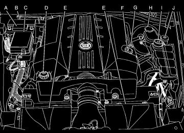
A. BAND Key. See “Finding a Station” under Navigation
Audio System on page 4-52.
B. CD Key. See Navigation Audio System on page 4-52
or CD/DVD Player on page 4-68.
C. DVD Key. See “Playing a DVD” under CD/DVD
Player on page 4-68.
D. TUNE/SEEK Key. See “Playing the Radio” under
Navigation Audio System on page 4-52.
E. Audio/Adjust Key. See “Main Audio Menu” under
Navigation Audio System on page 4-52.
F. Power-Volume Knob. See “Hard Keys” under Using
the Navigation System on page 4-10.
G. Navigation System Screen H. RPT (Repeat) Key. See “Hard Keys” under Using
the Navigation System on page 4-10.
I. MAP Key. See “Hard Keys” under Using the
Navigation System on page 4-10.
J. ROUTE Key. See “Hard Keys” under Using the
Navigation System on page 4-10.
K. MENU Key. See “Hard Keys” under Using the
Navigation System on page 4-10.
L. TILT Key. See “Hard Keys” under Using the
Navigation System on page 4-10.
4-3
{ CAUTION:
Taking your eyes off the road too long or too often while using the navigation system could cause a crash resulting in injury or death to you or others. Focus your attention on driving.
{ CAUTION:
Avoid looking too long or too often at the moving map on the navigation screen. This could cause a crash and you or others can be injured or killed. Use the turn-by-turn voice guidance directions whenever possible.
Getting Started Read this manual thoroughly to become familiar with how the navigation system operates. The navigation system includes navigation and audio functions. Keeping your eyes on the road and your mind on the drive is important for safe driving. The navigation system has built-in features intended to help you do this. Some features may be disabled while driving. Note, these functions are grayed-out. A grayed-out function indicates it is not available when the vehicle is moving. All functions are available when the vehicle is parked. Do the following before driving: (cid:129) Become familiar with the navigation system operation, hard keys on the faceplate, and touch-sensitive screen buttons of the navigation system.
(cid:129) Set up the audio by presetting favorite stations,
setting the tone, and adjusting the speakers.
(cid:129) Set up the navigation features before beginning driving, such as entering an address or a preset destination.
(cid:129) Set up the phone numbers in advance so they can be
called easily with the press of a single button or a single voice command (for navigation systems equipped with phone capability).
4-4
Use the navigation system to: (cid:129) Plan a route. (cid:129) Select a destination using various methods and
choices. Follow turn-by-turn route and map guidance with voice prompts, only if permitted by traffic laws, controls, and conditions.
Always be alert, obey traffic and roadway laws, and instructions, regardless of the guidance from the navigation system. Because the navigation system uses street map information that does not include all traffic restrictions or the latest road changes, it may suggest using a road that is now closed for construction or a turn that is prohibited by signs at the intersection. Because the system uses limited information, you must always evaluate whether following the system’s directions is safe and legal for the current conditions. When the navigation system is turned on, a screen may appear with the information below, and you must read and acknowledge the information it contains. After you acknowledge the start up information you will be able to access the NAV (navigation) and DEST (destination) functions. Once accessed, you can enter or delete information in the navigation system or access other functions. See instructions later in this section.
Deleting Personal Information This navigation system can record and store destinations. At times, such as when you are disposing of the vehicle, you may want to delete these destinations. Refer to the following sections to delete the destination information that has been stored. See “Deleting Single Memory Points”, “Deleting All Memory Points”, “Preset Dests.” (Destinations), “Home” and “Previous Dest.” (Destination) under Edit Memory Point on page 4-19 for deleting stored destinations. Storing Radio Station Presets To set preset radio stations: 1. Press the PWR/VOL knob to turn the system on. 2. Press the audio source screen button (AM, FM1, FM2, etc.) and select the desired band (AM, FM1, FM2, XM1, or XM2 (if equipped), or WX (weather) (if equipped)).
3. Use the TUNE/SEEK arrows to tune to the desired
station.
4. Press and hold one of the six preset screen buttons,
at the bottom of the screen, until a beep is heard or see the station displayed on the selected preset button.
5. Repeat the steps for each preset. See “Preset Station Menu” under Navigation Audio System on page 4-52 for more information.
4-5
(cid:129) Setting the Clock To set the time: 1. Press the PWR/VOL knob to turn the system on. 2. Press the e / z (Audio/Adjust) hard key. 3. Press the 8 clock symbol screen button. 4. Select the 12H or 24H screen button to display the
time in standard or military time.
5. Press and hold the HOUR and MIN. (minute) arrow
buttons to increase or to decrease the time.
6. Select the appropriate time zone screen button. 7. Select the Daylight Saving Time screen button,
if necessary.
The radio uses the GPS satellite to set the time. The vehicle needs to be in an open area to receive the signal. See “Clock Adjust Menu” under Navigation Audio System on page 4-52 for more information.
4-6
Setting the Search Area, Entering an Address and Point of Interest, Storing a Home Destination, and Using The Home or Previous Destinations Before entering an Address, Point of Interest, Home, or Preset Destination, select the appropriate region that contains the final destination. The vehicle must be stopped to perform this operation. Setting the Search Area To set the search area: 1. If the radio is already on with a map disc inserted,
skip to Step 5.
2. Press the PWR/VOL knob to turn the system on. 3. Insert the DVD map disc. See “Regional Maps” under Maps on page 4-38 for more information.
4. A notice may appear. Touch the I AGREE screen
button to proceed.
5. Press the ROUTE hard key. 6. Press the Enter Destination screen button. 7. Press the Change screen button. 8. Select the appropriate region numbered screen
button that contains your final destination.
The system returns to the Destination menu. See Enter Destination on page 4-27 for more information.
9. Select the desired street name with the correct
designation (Dr., Ln., St., etc.) from the list.
10. If there is more than one city, the system displays
the list of cities that have that street name. Select a city from the list or select the City screen button to input the city name.
11. Enter the house number using the numeric keypad
on the screen and touch the Enter screen button. The system lists the house number range available for the street.
12. Press the Enter screen button to plan the route. See “Address” under Enter Destination on page 4-27 for more information.
Entering an Address To set a destination by entering a street address: 1. If the radio is already on with a map disc inserted,
skip to Step 5.
2. Press the PWR/VOL knob to turn the system on. 3. Insert the DVD map disc. See “Regional Maps” under Maps on page 4-38 for more information.
4. A notice may appear. Touch the I AGREE screen
button to proceed.
5. Press the ROUTE hard key. 6. Press the Enter Destination screen button. Verify the selected Search Area is correct.
7. Press the Address screen button. 8. Press the Street screen button, then enter the
street name using the alpha keypad on the screen. Do not enter directional information or street type, and use the space screen button between street or city names. For example, the street name N. Royal Oak Rd. should be entered as royal oak. Use the backspace ( V ) screen button if an incorrect character has been entered.
4-7
Entering a Point of Interest (POI) To set a destination by entering a Point of Interest (POI): 1. If the radio is already on with a map disc inserted,
skip to Step 5.
2. Press the power/volume knob to turn the system on. 3. Insert the DVD map disc. See “Regional Maps” under Maps on page 4-38 for more information.
4. A notice may appear. Touch the I AGREE screen
button to proceed.
5. Press the ROUTE hard key. 6. Press the Enter Destination screen button. Verify the selected Search Area is correct.
7. Press the All Points of Interest screen button. 8. Enter the specific title of the POI in the Name space
(i.e. Washington Monument) using the alpha keypad on the screen.
9. Select the POI from the list. 10. Press the Enter screen button to plan the route.
Using the Category or City selections aid the system in finding your POI by limiting the search options.
See “All Points of Interest” under Enter Destination on page 4-27 for more information.
4-8
Storing a Home Destination 1. If the radio is already on with a map disc inserted,
skip to Step 5.
2. Press the power/volume knob to turn the system on. 3. Insert the DVD map disc. See “Regional Maps” under Maps on page 4-38 for more information.
4. A notice may appear. Touch the I AGREE screen
button to proceed.
5. Press the ROUTE hard key. 6. Press the Edit Memory Point screen button. 7. Press the Home screen button. 8. Press the Register screen button.
Select a method for entering a destination. See Enter Destination on page 4-27 for more information.
9. Press the Enter screen button to store the Home
destination. The L Home icon will be highlighted on the DESTINATION screen. See “Using The Home or Previous Destinations” next to use the home or previous destinations as a route.
Using The Home or Previous Destinations These destinations are available for selection while driving. 1. If the radio is already on with a map disc inserted,
skip to Step 5.
2. Press the power/volume knob to turn the system on. 3. Insert the DVD map disc. See “Regional Maps” under Maps on page 4-38 for more information.
4. A notice may appear. Touch the I AGREE screen
button to proceed.
5. Press the ROUTE hard key. 6. Press the Enter Destination screen button. Verify the selected Search Area is correct.
7. Select the L (Home symbol) or the Previous
Destination screen button. If the Previous Destination screen button is selected, a list of the last 10 previous destinations appear. Select the screen button next to the desired destination.
8. Press the Enter screen button to plan the route. See “Home” and “Previous Destination” under Enter Destination on page 4-27 for more information.
Canceling The Current Route Guidance is canceled once the final destination has been reached. To cancel the current route prior to arrival at the final destination: 1. Press the ROUTE hard key. 2. Press the Route Preference screen button. 3. Press the Cancel Route screen button. 4. Press the Yes screen button to confirm cancellation. Guidance Volume To adjust the volume of voice guidance prompts, do the following: 1. Press the MENU hard key. 2. Press the ON screen button to turn voice volume on. 3. Select the desired volume or select the OFF screen button. The system will play back the new volume level.
See “Voice Guidance Volume Settings” under Setup Menu on page 4-12 for more information.
4-9
Features and Controls
Using the Navigation System This section presents basic information needed to operate the navigation system. Use the keys located on each side of the navigation screen, as well as the available touch-sensitive screen buttons, to operate the system. See Navigation System Overview on page 4-2 for more information on location. Once the vehicle is moving, various functions become disabled to reduce driver distraction. Hard Keys The following hard keys are located to the left of the navigation screen:
BAND: Press to access the band screen and switch between AM, FM1, FM2, XM1, XM2, and WX (if equipped). See “Finding a Station” under Navigation Audio System on page 4-52.
CD: Press to play a CD. The CD screen displays. See Six-Disc CD Changer on page 4-65 or CD/DVD Player on page 4-68.
DVD: Press to play a DVD. The DVD screen displays. See CD/DVD Player on page 4-68. y TUNE/SEEK z: Press the up or down arrows to go to the next or previous radio station and stay there. See “Finding a Station” under Navigation Audio System on page 4-52. e / z (Audio/Adjust): Press to view the main audio menu. See “Main Audio Menu” under Navigation Audio System on page 4-52.
PWR-VOL (Power/Volume Knob): Press the knob to turn the audio and navigation systems on and off. Turn the knob to increase or decrease the volume to the audio system.
4-10
The following hard keys are located to the right of the navigation screen:
ROUTE: Press to display the PLAN ROUTE menu. See Plan Route on page 4-18.
RPT: Press to repeat the current voice guidance navigation prompt.
MAP: Press to view the map screen showing current vehicle position. The map screen can also display the following information: (cid:129) North or Heading Up symbol. See Symbols on
page 4-43.
(cid:129) Map scale. See Maps on page 4-38. (cid:129) Distance to destination. (cid:129) GPS symbol if GPS signal is not being received.
See Global Positioning System (GPS) on page 4-49.
(cid:129) Selected options for reaching your current
destination.
(cid:129) Driver Information. (cid:129) Radio band and presets.
MENU: Press to display the SETUP MENU. See Setup Menu on page 4-12. TILT X : Press to open the navigation system faceplate for loading or removing the map DVD, a video DVD, or an audio CD. This key can only be used while the vehicle is in P (Park). Alpha-Numeric Keypad Letters of the alphabet, symbols, punctuation, and numbers, when available, display on the navigation screen as an alpha or numeric keypad. The alpha keypad displays when the system needs a city or street name, entered. A Char at the bottom of the alpha keypad to access the numeric keypad can be touched when entering a house address, punctuation mark, or other character. Touch A - Z to return to the alpha keypad. All characters are touch-sensitive screen buttons. Touch a character to select it.
4-11
Setup Menu
MENU: Press this key, located to the right of the navigation screen, to access the SETUP MENU.
Map appearance, navigation settings, and voice guidance volume can be adjusted in the SETUP MENU.
Select the space symbol to enter a space between characters or the words of a name. V : Select the backspace symbol if an incorrect character has been selected. To make the name selections easier, the system only allows a selection of a character which can follow the last one entered. For example, if Z is entered, T could not be entered after it. The system highlights the available characters and darken the unavailable characters. If unsuccessful when entering a name, it may need to be entered differently. It is also possible that the map DVD database may not contain that information or the correct search area has not been selected. See Database Coverage Explanations on page 4-52 for more information. Touch Sensitive Buttons Touch-sensitive buttons are located on the screen. After successfully selecting a screen button, a beep is heard. These buttons highlight when a feature is available and are dim when not unavailable. There are some toggle screen buttons that are light blue when active and dark blue when inactive.
4-12
Navigation Settings This menu allows you to change the following options for the navigation system.
Restore Default Settings This feature automatically resets the system to the default values. To restore the default settings: 1. Touch the Restore Default Settings screen button. 2. Touch Enter. 3. Touch Return to exit this menu.
System Configuration This feature allows you to reconfigure the navigation system. If the vehicle is being driven during this procedure, the system will not be able to adjust the position or direction of the vehicle. Touch the System Configuration screen button to view:
Adjust Vehicle Position: To correct the position of the vehicle on the map or to change vehicle position: 1. Touch the Adjust Vehicle Position screen button.
The system displays Position Adjustment. The vehicle location symbol and the scroll symbol appear on the map.
2. Use the scroll symbol and the zoom in/zoom out feature to locate the vehicle position on the map.
3. Touch Enter to set the vehicle position. The system
displays Position Adjustment and two arrows appear on the map screen.
4. Touch the arrows to adjust the direction of the
vehicle. As you touch the arrows, the vehicle symbol direction changes.
5. When the vehicle has been set to the correct
direction, touch Enter. Relocation Complete displays.
6. Touch Return to exit this menu.
4-13
Quick POI (Point of Interest) Selection This menu allows you to choose a point of interest (POI), such as gas stations, restaurants, hotels, etc. to be displayed on the map screen. You can also set a destination to a specific POI.
Calibrate Vehicle Speed Signal: If there are tire pressure differences or if a spare tire is installed, the navigation system automatically recalibrates the system. To manually calibrate the system: 1. Touch Start to begin calibration. 2. Touch Return to exit this menu.
Time to Destination This feature allows you to view the estimated time to travel from your current position to the destination, and to reset the average speed to factory default settings. Estimated travel time is based on calculated route information and the vehicle’s average speed. Touch ON to turn this feature on, OFF to turn this feature off, or Reset to restore vehicle speed default settings. With this feature on, the estimated travel time to destination displays along with the distance to destination.
4-14
Setting the Quick POI Menu To set the Quick POI list displayed on the map screen: 1. Select the category to replace. 2. Select a Quick POI category from the Quick POI
selection menu list. The system returns to the Quick POI selection screen when a POI is selected.
3. Touch Return to save the setting and return to the
previous menu.
Displaying Quick POI Icons To display POI icons of a category on the map screen: 1. Touch the map screen once. 2. Touch the POI button. The Quick POI Selection list
displays.
3. Select a category type or touch List Categories or All Local POIs to display the icons of the selected category on the map screen.
Removing Quick POI Icons To remove POI icons from the map screen: 1. Touch the map screen once. 2. Touch the POI OFF screen button. The current POI
icons are removed from the map screen.
Setting a Destination Using Quick POI This feature allows you to choose a POI as the destination. To set a destination using a POI: 1. Touch the POI icon on the map screen to be set
as a destination. The selected icon is surrounded by a blinking box, and the name of the icon displays. You may also touch INFO to view the POI name, address, city, and phone number, if available. 2. Touch the ENT DEST screen button.
If a final destination has already been entered, the POI can be added as a waypoint. See Edit Waypoint on page 4-23 for more information.
3. Touch Enter to start planning the route. 4. To start route guidance, touch Start or begin driving
the vehicle. Route guidance automatically begins after a short distance.
To cancel the route that has just been set: 1. Press the ROUTE hard key. 2. Touch the Route Preference screen button. 3. Touch the Cancel Route screen button. 4. Select YES to cancel or NO to continue.
4-15
Guidance Appearance This menu allows you to set the guidance appearance screen options. This screen is displayed on the map while on a planned route. The current settings appear as light blue.
Turn List: Select to have the guidance screen display several upcoming turns. Directional arrows, street name, and distance to the next turn displays. As the next turn approaches, the system displays a closer view of the upcoming maneuver.
Arrow: Select to have the guidance screen display the next turn. A directional arrow, street name, and distance to the turn displays. As the turn approaches, the system displays a closer view of the upcoming maneuver.
2D: Select to display the guidance screen as a two-dimensional view.
3D: Select to display the guidance screen as a three-dimensional view.
Split Map: Select to display the guidance screen on the map at all times.
Full Screen: Select to display the guidance screen on the map when approaching a maneuver.
4-16
Map Appearance This menu allows you to set the map appearance screen options. The current setting appears as light blue.
Set 3D Viewing Angle: This feature allows you to adjust the 3D viewing angle. To do so: 1. Touch 3D on the MAP APPEARANCE menu. 2. Touch Set 3D Viewing Angle.
The map screen with the 3D viewing angle bar displays.
3. Touch the up or down arrows to set the viewing
angle.
4. Touch Return to save the settings and to exit this menu or touch Reset to restore the viewing angle to the default setting.
2D: Select to display the map as a two-dimensional view.
3D: Select to display the map as a three-dimensional view.
4-17
Plan Route To plan a route, press the ROUTE key. The PLAN ROUTE menu displays.
Voice Guidance Volume Settings This feature allows you to set the voice prompt volume level or to turn voice prompts on or off. Set the voice prompt volume level by touching the numbered buttons to increase or decrease the volume level. You may also choose to turn the voice prompts off. Then touch Return to save the setting and to return to the SETUP MENU. If a voice prompt is active while the audio system is on, the audio system volume decreases and the voice prompts are heard through the driver side front speaker. Voice prompts are not heard while using voice recognition.
One of several destination entry methods can be used to plan a route. See Enter Destination on page 4-27
for more information.4-18
Edit Memory Point This feature allows you to store, delete, and edit memory points. Touch the Edit Memory Point screen button from the PLAN ROUTE menu to access the EDIT MEMORY POINT screen.
Memory points can be stored in four different categories: personal, business, entertainment, and marked point. Memory points are stored when either START or MARK are selected when setting a destination on the map or when storing destinations in memory.
A total of 60 locations can be stored. The last 10 destinations entered are stored under Previous Destination. In addition, one memory point can be stored under the Home category. If all 60 stored points are entered, the system notifies you that there is no available storage left in memory points. A memory point must be removed before storing additional memory points. Registering Memory Points To store a memory point: 1. Select a category from the EDIT MEMORY
POINT menu.
2. Touch REGISTER. 3. Select a method for entering a destination. A map
appears displaying the memory point’s location.
4. If available, touch INFO to view the address
information for the memory point.
5. Touch Enter to store the point.
4-19
Editing Memory Points This feature allows you to edit the contents stored in memory. The following options are available: Icon Editing of a Memory Point Each memory point is displayed with a default icon. To edit an icon: 1. Select the category of the memory point. 2. Select the item to be edited. 3. Touch the icon. The EDIT MEMORY POINT icon
screen appears.
4. Touch the icon you would like to use. The system then returns to the EDIT MEMORY POINT menu. 5. Touch Return to go back to the previous screen. The new memory point icon displays on the map. Choose from 18 different icons, three of which are sound icons. The same icon may be used for other memory points as well.
Name Editing of a Memory Point To modify the name of a stored memory point: 1. Select the category of the memory point. 2. Select the item to be edited. 3. Touch the NAME screen button and use the alpha keypad to edit the name. Names may contain up to 15 alpha and/or numeric characters.
4. Touch Return to go to the previous screen. Moving Memory Points To move a memory point from one category to another: 1. Select the category of the memory point. 2. Select the memory point to be edited. 3. Touch CATEGORY. A list of categories appear.
The current category for the item will be highlighted and cannot be selected.
4. Touch the screen button for the category you want
the memory point placed in. A pop-up window appears displaying the change in category.
5. Touch Return to go back to the previous screen.
4-20
Adjusting a Memory Point To relocate a memory point’s location: 1. Select the category of the memory point. 2. Select the memory point to be edited. 3. Touch POSITION. A map screen with the position
of this memory point appears.
4. Touch anywhere on the screen to activate the scroll
feature and relocate the memory point. See Maps on page 4-38.
5. Touch Enter to save the memory point’s new
location.
6. Touch Return to go back to the previous screen. Changing the Phone Number of a Memory Point To edit or add the phone number of a memory point: 1. Select the category of the memory point. 2. Select the memory point to be edited. 3. Touch PHONE and use the numeric keypad to edit
or add the number.
Deleting Single Memory Points To delete a single memory point: 1. Press the ROUTE key. 2. Touch EDIT MEMORY POINT. 3. Select the category of the memory point. 4. Touch DELETE. 5. Select the memory point to be deleted.
A confirmation window appears.
6. Touch YES to delete the memory point or NO to
return to the previous menu.
7. Touch Return to go back to the previous screen. Deleting All Memory Points To delete all of the memory points in a category: 1. Press the ROUTE key. 2. Touch EDIT MEMORY POINT. 3. Select the desired category. 4. Touch the DELETE ALL screen button.
A confirmation window appears.
4. Touch the RETURN button to take you back to the
previous screen when finished.
5. Touch YES to delete the memory points or NO to
return to the previous menu.
6. Touch Return to go back to the previous screen.
4-21
Edit Category To edit the name of a category: 1. Press the ROUTE key. 2. Touch EDIT MEMORY POINT. 3. Select the category to be edited. 4. Touch the EDIT CATEGORY screen button and use the alpha keypad to edit the category name. The name can consist of up to 15 alpha and/or numeric characters.
5. Touch Return to go back to the previous screen. Marked Point A marked point is a memory point which has been stored by selecting the MARK screen button while traveling on a planned route. The scroll feature can also be used to plan a destination on the map after reaching the destination, or by moving a memory point to a marked point category. See “Editing Memory Points” earlier in this section for more information.
Previous Destination Memory Each time Start is selected from the map screen, that destination is stored as a memory point under PREVIOUS DESTINATION. This category stores up to 10 destinations. When the Previous Destination category contains more than 10 destinations, the system removes the oldest destination stored and adds the most recent one selected to the list. So that a previous destination is not lost, move the destination into a memory point category. See “Moving Memory Points” earlier in this section for more information. Home Memory This memory point is stored by selecting Home from the EDIT MEMORY POINT screen. See “Registering Memory Points” earlier in this section and “Home” under Enter Destination on page 4-27 for more information.
4-22
Edit Waypoint Waypoints are destinations you can set along the way to your final destination. This feature allows you to add, edit, and delete waypoints.
Adding a Waypoint To add a waypoint to the route: 1. Touch Add Waypoint. 2. Enter a destination. See Enter Destination on
page 4-27. A map appears showing the location of the waypoint.
3. Touch Enter to add the waypoint. 4. Touch the ADD screen button to insert the waypoint
in the desired order.
5. The system displays the ROUTE INFORMATION
screen. From this screen, several options are available.
Five waypoints can be set up on the way to the final destination. To access the WAYPOINT menu: 1. Press the ROUTE key. 2. Touch Edit Waypoint.
4-23
Delete: Touch to delete a waypoint or the final destination. A confirmation window appears. Touch YES to delete the point or NO to return to the previous screen.
Delete All: Touch to delete all of the waypoints and the final destination. A confirmation window appears. Touch YES to delete all waypoints or NO to return to the previous screen.
Change: Touch Change to change the final destination. Enter a destination. See Enter Destination on page 4-27.
Add: Touch to add additional waypoints. Refer to the steps for adding a waypoint listed previously in this section.
Calculate: Touch to begin route calculation. This feature is only available if the final destination has been set.
List: Touch to view the waypoint on the map or to change the order of the waypoints and final destination. To change the order, touch CHG ORDER, then touch the blank screen button next to the destination to select the order of the waypoints and final destination. Press the MAP key to view the destination and waypoints on the map screen.
4-24
Editing a Waypoint This feature allows editing of waypoints that have already been set. To edit a waypoint: 1. Touch Edit Waypoint. 2. Touch the MAP key to view the destination location
on the map screen.
3. Touch CHANGE ORDER to change the order of the
waypoints and the final destination. The map scroll can be used to change a waypoint from one location to another.
Deleting a Waypoint To delete a waypoint from the route: 1. Touch Delete Waypoint. 2. Select the waypoint to be deleted. A confirmation
window appears.
3. Touch YES to delete the waypoint or NO to return
to the previous menu.
Edit Avoid Point/Area From this menu you can register, edit, and delete an area to be avoided while planning a route. These areas can also be saved so the system can automatically avoid them when planning a route.
To access the AVOID POINT/AREA menu: 1. Press the ROUTE key. 2. Touch Edit Avoid Point/Area.
4-25
Registering an Avoid Point/Area To store an avoid point/area: 1. Touch Register Avoid Point/Area. 2. Enter a location. See Enter Destination on
page 4-27.
3. If desired, reduce or enlarge the area around the point you want to avoid by using the REDUCE or ENLARGE screen buttons. If an avoid point cannot be avoided, the system displays “Avoid Point and Area Stored. Route May Not Avoid the Avoid Point and Areas.”
4. Touch Enter to set the area as an avoid point area. When using the REDUCE or ENLARGE buttons, a box appears to represent the area or an X appears to represent the area avoided. When an avoid point is set, the square will appear as green.
5. Touch Return to go back to the previous screen.
Editing an Avoid Point/Area To edit an avoid point/area: 1. Touch Edit Avoid Point/Area. A list of avoided
points appear.
2. Select the avoided point/area you want to change.
A map of the avoided area appears.
3. Use REDUCE or ENLARGE to edit the avoided
point.
4. Touch Enter to set your new avoided area.
The system displays “Area Adjusted.”
5. Touch Return to go back to the previous screen. Deleting an Avoid Point/Area To delete an avoid point/area: 1. Touch Delete Avoid Point/Area. A list of avoided
points appear.
2. Select the avoided point/area to be deleted. 3. The system will ask to confirm the selection. Touch Yes to delete the avoid point/area or No to cancel. If Yes is selected, the area will no longer be avoided when traveling on a planned route.
4. Touch Return to go back to the previous screen.
4-26
Enter Destination The DESTINATION menu gives you several ways to plan a route. Touch the Enter Destination screen button from the PLAN ROUTE menu to display the DESTINATION menu.
For destination entry methods listed on the second page of the DESTINATION menu, touch the Next Page arrow. Touch the Prev. Page arrow to return to the first page.
To enter a destination, choose from one of the destination entry methods following in this section. After entering a destination, If available, the system displays up to three routes in a pop-up window indicating the total mileage and time to destination for each route. Select a route by touching NEXT. The map displays each route in a different color. The selected route highlights in red. To start route guidance, touch Start or begin driving the vehicle. Route guidance automatically begins after a short distance. If CHG ROUTE is touched before touching Start, route preferences can be changed. See Route Preference on page 4-36 for more information. When a route has been planned, it highlights and a bulls-eye symbol appears on the map to show the final destination. To cancel a route that has been set, see “Cancel Route” under Route Preference on page 4-36.
4-27
Easy Planning Route With this destination entry method, a destination can be selected by using the scroll symbol on the map screen. See Maps on page 4-38.
3. Touch the map screen continuously to scroll
through the map faster. The address of the location on the map appears at the top of the screen. If needed, use the zoom feature to locate the destination. See “Map Scales” under Maps on page 4-38 for more information.
4. Touch ENT DEST to set this location as the destination. Touch MARK to also store this location as a memory point.
5. Touch Enter to plan the route.
To use this destination entry method: 1. Press the MAP key. 2. Touch the map screen twice for the scroll symbol to
appear. Touch the map or drag the scroll symbol toward the destination.
4-28
Address This destination entry method allows input of an address by providing the system with a house number, street name, and city. Select Street to begin entering the desired address.
To use this destination entry method: 1. Enter the street name using the alpha keypad. See “Alpha-Numeric Keypad” under Using the Navigation System on page 4-10 for more information.
Do not include name extensions such as N. or Drive. For example, the street name N. Civic Center Drive should be entered as Civic Center. As information is entered, the system automatically searches for available names, and List becomes available.
2. Touch List to view name choices or continue to
spell the street name to further reduce the number of available items. Select a street name.
3. If the street name entered exists in more than one
city on the DVD database, a list of cities appear. Select a city from the list, or enter the city name by selecting City. While entering the city name, the desired city can be selected from the list which appears, or continue to spell the city name to further reduce the number of available items.
4. Once the city name has been selected, enter the
house number using the numeric keypad. The system lists the house number range that is available for the street.
5. After entering all of the address information, touch
Enter to plan the route.
4-29
All Points of Interest This destination entry method allows you to choose a destination from the point of interest (POI) list. Selecting All Points Of Interest from the DESTINATION menu brings up the alpha keypad. While inputting a POI or city name, the List option will become available. As information is entered, the system searches for available POI and city names based on the information given. The system supplies a list of names to make a selection from when the choices are five or less.
You may search for a POI using the following three methods:
Touch NAME to type in a POI by name using the alpha key pad. As you type in a name, the system searches for an available match to your input. Select the desired POI.
(cid:129) Select a POI by touching CATEGORY. Use the
arrows to scroll through the categories listed. Select a category along with any appropriate sub-categories. If the list of available POIs for the selected category is too long, the POI’s name or city may need to be entered.
(cid:129) Select CITY, then type in the city from which a POI is
selected. Choose a city from the list of cities that appears. If the list of POIs for the selected city is too long, enter the POI’s name or choose a category.
While entering a POI or city name, the List option becomes available. Touch List to view the list of name choices, or continue to spell the name to further reduce the list of available items.
4-30
(cid:129) The system lists all POIs available. Sort by name using NAME SORT or touch DIST SORT to list POIs by distance from the current location.
Memory Points This destination entry method allows a memory point to be set as the destination. Each time a destination from the map screen is stored, the destination is stored under MARKED POINT. See Edit Memory Point on page 4-19 for more information.
Select a location from the list. The system shows the selected POI on the map. If available, a pop-up window displays. Touch INFO to view the POI’s name, address, city, and phone number, if available. Touch Enter to plan the route.
Destinations must be stored as memory points to select from PERSONAL, BUSINESS, ENTERTAINMENT, or MARKED POINT. If you have renamed the memory point category name(s), the name(s) appear as you changed them.
4-31
To select a destination using this entry method: 1. Touch the Memory Points symbol. 2. Select a category. 3. Select a destination. Use the arrows to scroll
through the memory points. They can be sorted by date, name, distance, and icon.
4. Touch Enter to plan the route. Previous Destination This destination entry method allows selection of a destination by choosing from a list of the last 10 destinations entered into the system.
To select a previous destination: 1. Touch the Previous Destination symbol. 2. Touch the screen button next to the desired
destination to select it. Use the arrows if necessary to view the entire list of previous destinations.
3. Touch Enter to plan the route. Previous Starting Point This destination entry method allows selection of the last start point as the destination. To select the previous start point as the destination: 1. Touch Previous Destination. 2. Touch the Previous starting point screen button. 3. Touch Enter to plan the route.
4-32
Home This destination entry method allows selection of a destination that has been previously stored as Home.
Set by Map This destination entry method allows selection of a destination by using the scroll symbol.
To choose Home as the destination: 1. Touch the Home symbol. 2. Touch Enter to plan the route.
To use this feature: 1. Touch the Set By Map symbol. Current vehicle
position is shown on the map screen.
2. Use the scroll symbol to select the desired
destination. The zoom in and zoom out feature can be used to assist in finding the desired location. See “Map Scales” under Maps on page 4-38.
3. Touch Enter to plan the route.
4-33
3. Touch List to view the list of available name choices
or continue to spell the name to further reduce the list of available items. The system supplies a list of names when the choice is five or less. If unsuccessful when inputting a name, the name may need to be input differently, the map DVD database may not contain this information, or the name may be misspelled.
4. Select a freeway from the list. 5. The ENTRANCE or EXIT options will appear. Choose ENTRANCE to select the entrance to the freeway, or EXIT to select the exit ramp of the freeway. When either button is touched, it gives an alphabetical list of freeway entrance and exit ramps on the freeway that were entered. Touch DIST SORT to sort the list by distance from the current location, or NAME SORT to sort the list by name.
6. Select the desired freeway entrance or exit from the
list. A map appears with the destination shown.
7. Touch Enter to plan the route.
Freeway Entrance/Exit This destination entry method allows selection of either a freeway entrance or an exit as a destination.
To enter a freeway name: 1. Touch the Freeway Entrance/Exit symbol. 2. Enter the freeway name using the alpha key pad. Freeways sometimes have a name and a number associated with them which may need to be referred to when entering freeway information. Freeways are also referred to by their abbreviated names. For example, Interstate 75 in the U.S. is selected by entering I-75. While entering a freeway name, the List option becomes available.
4-34
Intersection This destination entry method allows selection of a destination by inputting the intersecting roads of the destination.
To enter an intersection: 1. Touch the Intersection symbol. 2. Using the alpha keypad, enter the name of the first
street in the intersection.
3. To view a list of choices, touch List or continue to
spell the name to further reduce the list of available items. The system will display a list of the intersecting streets if the number of intersecting streets is five or less. 4. Select the first street. 5. Now enter the second street name. 6. Select the second street name from the list of intersecting streets. To view a list of choices, touch List or continue to spell the name to further reduce the list of available items. The system displays a list of intersecting streets if the number of intersecting streets is five or less. If there are multiple intersections with the same two roads, the system displays a list of cities to choose from. Choose a city from this list. A map with the intersections for that city appears.
7. Touch Enter to plan the route.
4-35
Route Preference To change the planning options:
The following options are available from the ROUTE PREFERENCE menu: Detour This feature allows you to choose a distance in miles/kilometers to detour. Select the detour distance desired for residential roads and freeways.
1. Press the ROUTE key. 2. Touch Route Preference.
4-36
These settings are retained the next time Detour is used until the settings are changed. Alternate can also be touched to provide a new route that does not use previously stored detour settings. Touch Return to go back to the previous screen.
Route Setting This feature displays and changes the planning methods used each time you plan a route. Planning method options, allowing selection of the fastest route based on time or distance, using only major roads, toll roads, and using ferries based on the navigation system’s information and information contained on the map DVD.
The following options are available from the ROUTE SETTING menu:
Minimize Time/Distance: The system calculates the fastest route or shortest route possible. Choose Time for the fastest route or Dist for the shortest route.
Use Major Roads: Choose Yes to calculate the best route using only major roads unless a route cannot be found without the use of a secondary road. This selection will not always offer the shortest distance or time to your destination. Use Toll Roads: Choose Yes to calculate the best route using toll roads wherever possible. This selection will not always offer the shortest distance or time to your destination. Use Ferries: Choose Yes to calculate the best route using ferries when possible. This selection will not always offer the shortest distance or time to your destination. Display Whole Route This feature allows the entire planned route to be displayed. Total mileage and time to destination for the planned route displays on the map screen. Touch Return to go back to the previous menu. Calculate Route This feature allows route calculation for the selected destination. Cancel Route To cancel a planned route while traveling on it, touch Cancel Route. The system will ask for confirmation by touching YES. Touch YES to confirm cancellation of the planned route or touch Return to keep the planned route.
4-37
Maps This section includes basic information needed to understand the map database. The maps are stored on a DVD-ROM. The 48 contiguous United States and portions of Canada are contained on two discs. To minimize the necessity of changing the discs, both map discs cover US6, US7, and Canada.
East
West
4-38
Installing the DVD Map Disc Your dealer/retailer may have installed the map DVD. If the map DVD was not installed, do the following to load it: 1. Turn the ignition on. 2. With the vehicle in P (Park), press and hold the
TILT key until a beep is heard. The system’s faceplate opens.
3. If already loaded, the map DVD or a CD ejects from
the slot.
4. Load the map DVD into the slot by inserting it
partway. The system pulls it in.
5. Press and release the TILT key to close the
faceplate.
Notice: Shifting out of P (Park) with the system’s faceplate open will cause the faceplate to close automatically. This could cause damage to a CD, DVD or the system if it is partially loaded. Before shifting out of P (Park), make sure that the DVD or CD is loaded properly. The vehicle must be shifted back into P (Park) to close the faceplate. Once the map DVD is inserted correctly, you will have the following two choices:
LANGUAGE I AGREE
The language can be changed at this time. See “Language” under Navigation Audio System on page 4-52 for more information on choosing a language. Once a language has been selected, touch I AGREE to plan a route. The map appears showing the current vehicle position.